Whitby in the Domesday Book (1086)
Whitby appears in the Domesday Book of 1086, entered under the hundred of Langbaurgh in Yorkshire.
Other Settlements in Langbaurgh
- Acklam
- Airy [Holme]
- Aislaby
- Arnodestorp
- Baldebi
- Barnaby
- Barwick
- Battersby
- Bergolbi
- Berguluesbi
- Blaten [Carr]
- Borrowby
- Breck
- Brotton
The Meaning of the Name
The name Whitby is of Scandinavian origin. Its final element derives from the Old Norse word bý, a farmstead or village. The first element is most likely a personal name or an early descriptive term, now difficult to recover with certainty. Taken together the name probably meant something close to ‘a farmstead’.
Names of this type are a fingerprint of Scandinavian settlement: they cluster across the old Danelaw, where Norse-speaking settlers renamed or founded villages from the late 9th century onward.
Remarkably, the name has changed little since 1086, when the Domesday scribes wrote it as Whitby.
Listed Buildings Near Whitby
Historic England records 405 listed buildings within about a mile of Whitby. Listing protects structures of special architectural or historic interest, graded I (exceptional), II* (particularly important) and II.
Grade I
- Whitby Abbey (Ruins) - 0.38 km
- Whitby Abbey Cross - 0.41 km
- Garden Walls and Gatepiers to the Abbey House - 0.45 km
- Parish Church of St Mary - 0.5 km
- Youth Hostel - 0.51 km
- The Abbey House - 0.52 km
- Donkey Road - 0.59 km
- The Church Stairs - 0.59 km
Grade II
- 28 and 30, Henrietta Street - 0.5 km
- 26, Henrietta Street - 0.51 km
- Fortunes Whitby Kippers - 0.52 km
- 20, Henrietta Street - 0.53 km
- 37, Henrietta Street - 0.53 km
- 35, Henrietta Street - 0.54 km
- Morland Cottage - 0.55 km
- 12 and 14, Henrietta Street - 0.55 km
- 16 and 18, Henrietta Street - 0.55 km
- 6-10, Henrietta Street - 0.56 km
- 23-29, Henrietta Street - 0.57 km
- 4, Henrietta Street - 0.58 km
- Workshop Owned by Number 14 Blackburn’s Yard - 0.59 km
- No 14 Blackburn’s Yard - 0.59 km
- 1, Church Lane - 0.6 km
- East Pier - 0.6 km
…and 381 more listed structures in the area.
Scheduled Monuments Near Whitby
Scheduled monuments are nationally important archaeological sites given legal protection. 2 lie within roughly a mile of Whitby:
- Whitby Abbey: Saxon double-house, post-Conquest Benedictine monastery, C17 manor house and C14 cross. - 0.42 km
- Saltwick Nab alum quarries - 0.87 km
Whitby Today
Today Whitby lies within the administrative area of North Yorkshire, and the settlement recorded a population of 13,130 at the 2021 census. Nine and a half centuries separate that figure from the small rural community the Domesday survey recorded here in 1086.
Read more about modern Whitby on Wikipedia .
Nearby Domesday Settlements
Other places recorded in the 1086 survey within a few miles:
- Baldebi - 0.0 km N
- Breck - 0.0 km N
- Prestby - 0.0 km N
- Sowerby - 0.0 km N
- Flowergate - 1.0 km W
- High Stakesby - 2.2 km SW
Heritage Around Whitby
Photographs of churches, listed buildings and monuments in the vicinity, contributed by volunteers to the Geograph project and reused here under a Creative Commons licence.
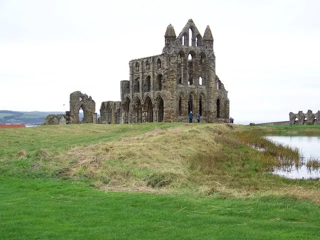
© Maigheach-gheal · Geograph · CC BY-SA 2.0
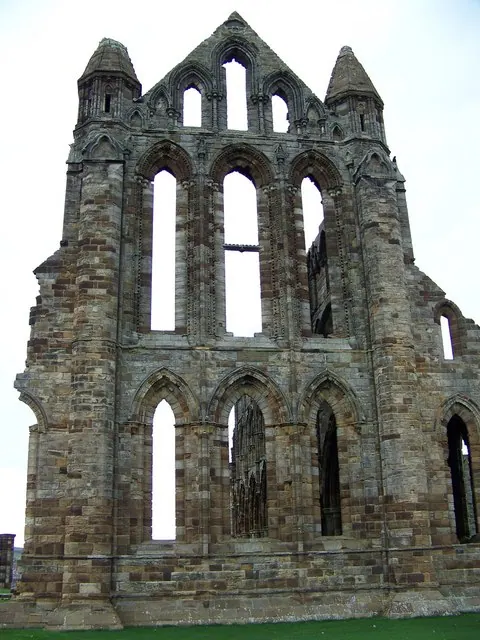
© Maigheach-gheal · Geograph · CC BY-SA 2.0
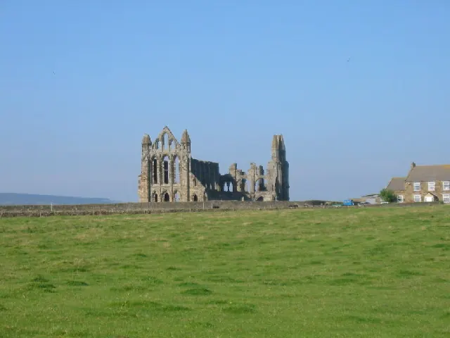
© Colin Westley · Geograph · CC BY-SA 2.0
Images © their respective photographers, licensed under CC BY-SA 2.0 and reused here with attribution. Photographs depict listed buildings, churches and monuments near this settlement and may show neighbouring villages.
Data derived from the Open Domesday project (opendomesday.org), based on the Domesday Book dataset compiled by Professor J.J.N. Palmer and team. The Domesday Book (1086) is in the public domain.
Found an inaccuracy? [email protected]