Walton Hall in the Domesday Book (1086)
Walton Hall is named in the Domesday Book, compiled by Norman commissioners in 1086, entered under the hundred of Amounderness in Yorkshire.
Other Settlements in Amounderness
- Aighton
- Aldcliffe
- Aldingham
- Arkholme
- Aschebi
- Ashton [Hall]
- Ashton [on Ribble]
- Austwick
- Barbon
- Bardsea
- Bare
- Barnoldswick
- Barton
- Beetham
The Meaning of the Name
The name Walton Hall is of Anglo-Saxon origin. Its final element derives from the Old English word tūn, a farmstead or village. The first element is most likely a personal name or an early descriptive term, now difficult to recover with certainty. Taken together the name probably meant something close to ‘a farmstead’.
Remarkably, the name has changed little since 1086, when the Domesday scribes wrote it as Walton Hall.
Listed Buildings Near Walton Hall
Historic England records 38 listed buildings within about a mile of Walton Hall. Listing protects structures of special architectural or historic interest, graded I (exceptional), II* (particularly important) and II.
Grade II
- High Bank Side Farmhouse and Outbuilding - 0.53 km
- Orchard Rise - 0.62 km
- Bee Boles Approximately 13.5 Metres to East of Orchard Rise - 0.63 km
- Howbarrow Farmhouse - 0.72 km
- Hill Farmhouse - 0.78 km
- Well Knowe House and Farmhouse - 1.01 km
- Underpass Approximately 120 Metres North West of Whitegate Cottages - 1.08 km
- Whitegates Cottages - 1.08 km
- North Lodge and Gate Piers to Holker Hall - 1.12 km
- Park Beck Cottage - 1.23 km
- Park House - 1.23 km
- Post Office - 1.24 km
- Parkside House and Adjacent Barn - 1.24 km
- Village Lock-up - 1.25 km
- Wharton - 1.25 km
- Priory Guesthouse and Shop (Tarragon) and Cobbled Paving - 1.25 km
- Old Barn Cottage and Cobbled Paving - 1.25 km
- Thimble Hill - 1.26 km
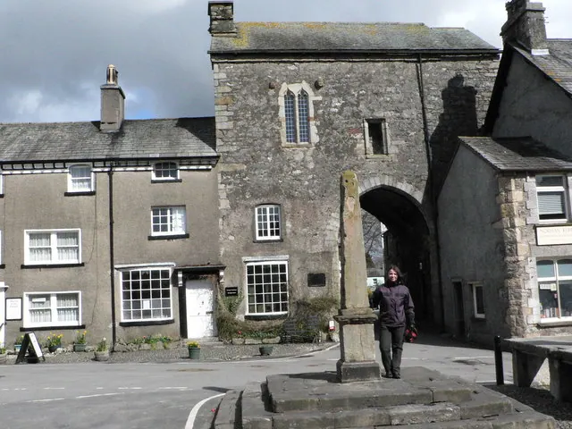
- Cross and Fish Stone - 1.26 km
- Market Cross Cottage and Gatehouse (West Bay) - 1.26 km
- Bank Court P Smith’s Bookshop Town Close, With Decorative Cobbled Paving - 1.26 km
- 5, Park View - 1.26 km
- Former National Westminster Bank and Nat West Bank House and Cobbled Paving - 1.27 km
- Tower Cottage and Bay to Left, Part of Gatehouse - 1.27 km
…and 14 more listed structures in the area.
Scheduled Monuments Near Walton Hall
Scheduled monuments are nationally important archaeological sites given legal protection. 1 lies within roughly a mile of Walton Hall:
Nearby Domesday Settlements
Other places recorded in the 1086 survey within a few miles:
- Cartmel - 1.0 km E
- Holker - 1.0 km S
- Birkby Hall - 1.4 km SE
- High Newton - 6.4 km NE
- Bardsea - 7.2 km SW
- Ulverston - 8.0 km W
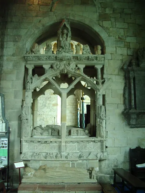
Heritage Around Walton [Hall]
Photographs of churches, listed buildings and monuments in the vicinity, contributed by volunteers to the Geograph project and reused here under a Creative Commons licence.
© John Berry · Geograph · CC BY-SA 2.0
© Alexander P Kapp · Geograph · CC BY-SA 2.0

© David Long · Geograph · CC BY-SA 2.0
Images © their respective photographers, licensed under CC BY-SA 2.0 and reused here with attribution. Photographs depict listed buildings, churches and monuments near this settlement and may show neighbouring villages.
Data derived from the Open Domesday project (opendomesday.org), based on the Domesday Book dataset compiled by Professor J.J.N. Palmer and team. The Domesday Book (1086) is in the public domain.
Found an inaccuracy? [email protected]