Tarvin in the Domesday Book (1086)
The 1086 Domesday survey records the settlement of Tarvin, entered under the hundred of Rushton in Cheshire.
Other Settlements in Rushton
- Alpraham
- Alretone
- Ashton
- Beeston
- Bunbury and [Lower] Bunbury
- Burton
- Clotton
- Cocle
- Iddinshall
- Opetone
- Oulton
- Over
- Peckforton
- Rushton
The Meaning of the Name
The origin of the name Tarvin is not securely established from its modern form alone; like many settlement names in the North it likely combines an Old English or Old Norse personal name with a landscape term.
Remarkably, the name has changed little since 1086, when the Domesday scribes wrote it as Tarvin.
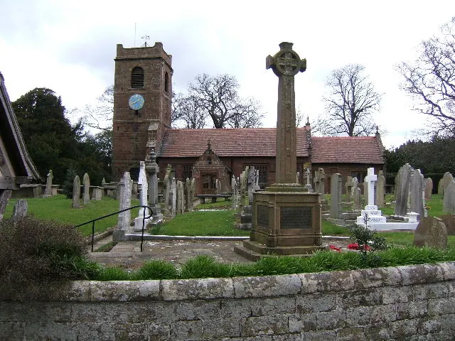
Listed Buildings Near Tarvin
Historic England records 27 listed buildings within about a mile of Tarvin. Listing protects structures of special architectural or historic interest, graded I (exceptional), II* (particularly important) and II.
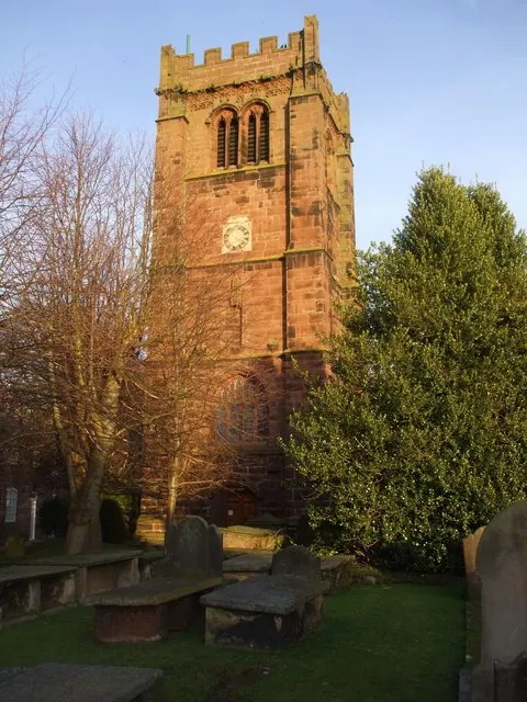
Grade I
- Church of St Andrew - 0.78 km
Grade II*
- Tarvin Hall - 0.63 km
- The Flaggs and Hamilton House, and Front Garden Walls and Gates - 0.71 km
Grade II
- 51, High Street - 0.62 km
- Roade House - 0.63 km
- Laurel House - 0.67 km
- G Gunnery and Son - 0.68 km
- Red Lion - 0.69 km
- 76, High Street - 0.7 km
- Number 86 and Attached Outbuilding - 0.7 km
- 54, High Street - 0.7 km
- 78 and 80, High Street - 0.72 km
- Church Cottages - 0.72 km
- Church House - 0.73 km
- Gates and Gatepiers to the Churchyard of St Andrew - 0.74 km
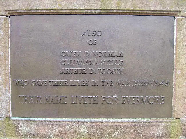
- Tarvin War Memorial - 0.74 km
- Tombchest of William and Elizabeth Hilton, 17 Metres West of West Door of Church of St Andrew - 0.75 km
- Tombchest of John Minshull and Daughter, South West Corner of Churchyard of St Andrew - 0.75 km
- Holme Bank - 0.76 km
- Church Hall, Grammar School House and the Hearse House - 0.76 km
- Tombstone of Beatrix Hollinsworth 12 Metres West Door of Church of St Andrew - 0.76 km
- Tombchest of William Sandbach and Others, 5 Metres South East of Sundial in Churchyard of St Andrew - 0.77 km
- Sundial in the Churchyard of St Andrew - 0.77 km
- The Vicarage - 0.8 km
…and 3 more listed structures in the area.
Tarvin Today
Today Tarvin lies within the administrative area of Cheshire West and Chester, and the settlement recorded a population of 3,286 at the 2021 census. Nine and a half centuries separate that figure from the small rural community the Domesday survey recorded here in 1086.
Read more about modern Tarvin on Wikipedia .
Nearby Domesday Settlements
Other places recorded in the 1086 survey within a few miles:
- Great and Little Barrow - 2.8 km NW
- Ashton - 2.8 km NE
- Stapleford - 3.0 km S
- Guilden Sutton - 4.1 km W
- Cocle - 4.1 km E
- Mickle Trafford - 4.5 km NW
Heritage Around Tarvin
Photographs of churches, listed buildings and monuments in the vicinity, contributed by volunteers to the Geograph project and reused here under a Creative Commons licence.
© BrianPritchard · Geograph · CC BY-SA 2.0
© BrianPritchard · Geograph · CC BY-SA 2.0
© John Lord · Geograph · CC BY-SA 2.0
Images © their respective photographers, licensed under CC BY-SA 2.0 and reused here with attribution. Photographs depict listed buildings, churches and monuments near this settlement and may show neighbouring villages.
Data derived from the Open Domesday project (opendomesday.org), based on the Domesday Book dataset compiled by Professor J.J.N. Palmer and team. The Domesday Book (1086) is in the public domain.
Found an inaccuracy? [email protected]