Shotwick in the Domesday Book (1086)
The 1086 Domesday survey records the settlement of Shotwick, entered under the hundred of Willaston in Cheshire.
Other Settlements in Willaston
The Meaning of the Name
The name Shotwick is of Anglo-Saxon origin. Its final element derives from the Old English word wīc, a dwelling, dairy farm or trading settlement. The first element is most likely a personal name or an early descriptive term, now difficult to recover with certainty. Taken together the name probably meant something close to ‘a specialised farm’.
Remarkably, the name has changed little since 1086, when the Domesday scribes wrote it as Shotwick.
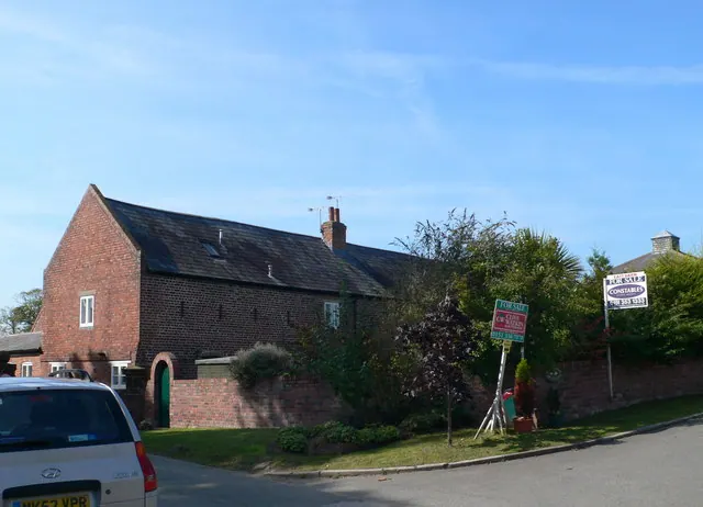
Listed Buildings Near Shotwick
Historic England records 21 listed buildings within about a mile of Shotwick. Listing protects structures of special architectural or historic interest, graded I (exceptional), II* (particularly important) and II.
Grade I
- Church of St Michael - 0.32 km
Grade II*
- Front Garden Walls and Gatepiers at Shotwick Hall - 0.59 km
- Shotwick Hall - 0.61 km
Grade II
- Tombchest of James Phillips, 2 Metres South of the Sundial in the Churchyard of St Michael - 0.29 km
- Gates, Gatepiers and Churchyard Wall Along North Side of Shotwick Lane - 0.29 km
- Sundial in the Churchyard of St Michael - 0.29 km
- Tombchest of Robert and Martha Ellison, 10 Metres South West of South West Corner of Tower of Church of St Michael - 0.3 km
- Tombchest of John Nevett Bennett, 8 Metres South of South Porch of St Michael’s Church - 0.3 km
- Tombchest of William Briscoe (Died 1723) and Others, 4 Metres West of Priest’s Door to St Michael’s Church - 0.31 km
- Tombchest of William Briscoe (Died 1704) and Others 5 Metres South West of Priest’s Door to St Michael’s Church - 0.31 km
- Tombchest of Rev M Reay and 4 Children, 5 Metres West of South Porch of St Michael’s Church - 0.31 km
- Church Cottage and Attached Outbuildings - 0.33 km
- Church House Farmhouse - 0.33 km
- Woodbine Cottage - 0.35 km
- Vicarage Farmhouse - 0.37 km
- Greyhound Farmhouse - 0.39 km
- Manor Farmhouse - 0.41 km
- Stone Cottage and Attached Outbuilding and Boundary Wall - 0.43 km
- Former Kitchen or Bakehouse Attached to North East Corner of Shotwick Hall - 0.62 km
- Derelict Stable 45 Metres North of Shotwick Hall - 0.65 km
- L-shaped Ranges of Farmbuildings 60 Metres North of Shotwick Hall - 0.67 km
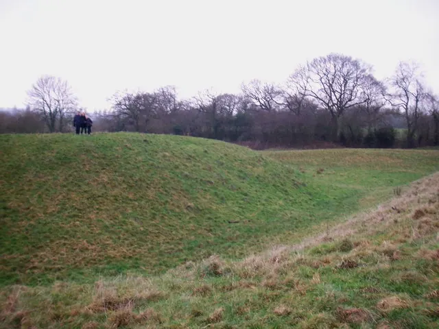
Scheduled Monuments Near Shotwick
Scheduled monuments are nationally important archaeological sites given legal protection. 1 lies within roughly a mile of Shotwick:
- Shotwick Hall moated site - 0.56 km
Shotwick Today
Today Shotwick lies within the administrative area of Puddington.
Read more about modern Shotwick on Wikipedia .
Nearby Domesday Settlements
Other places recorded in the 1086 survey within a few miles:
- Puddington - 2.2 km NW
- Great and Little Saughall - 3.2 km E
- Capenhurst - 3.6 km NE
- Ledsham - 3.6 km NE
- Wepre - 4.5 km SW
- Ness - 5.0 km NW
Heritage Around Shotwick
Photographs of churches, listed buildings and monuments in the vicinity, contributed by volunteers to the Geograph project and reused here under a Creative Commons licence.
© Peter Whatley · Geograph · CC BY-SA 2.0
© John Hughes · Geograph · CC BY-SA 2.0
© Eirian Evans · Geograph · CC BY-SA 2.0
Images © their respective photographers, licensed under CC BY-SA 2.0 and reused here with attribution. Photographs depict listed buildings, churches and monuments near this settlement and may show neighbouring villages.
Data derived from the Open Domesday project (opendomesday.org), based on the Domesday Book dataset compiled by Professor J.J.N. Palmer and team. The Domesday Book (1086) is in the public domain.
Found an inaccuracy? [email protected]