Sheriff Hutton in the Domesday Book (1086)
Sheriff Hutton is named in the Domesday Book, compiled by Norman commissioners in 1086, entered under the hundred of Bulford in Yorkshire. The survey assessed Sheriff Hutton at 34.9 carucates of taxable land.
At the time of the survey, Sheriff Hutton supported a recorded population of 31 villagers, 41 smallholders, 26 slaves, working 32 ploughs between them.
By 1086 Sheriff Hutton was worth 40.5 shillings, up from 17.5 shillings before the Conquest – in contrast to many Yorkshire neighbours whose valuations collapsed.
The survey lists 2 manors at Sheriff Hutton under different lords. Splitting a single settlement between multiple tenants was common across the North – Saxon estates broken up and handed to William’s followers after 1066.
Resources Recorded at Sheriff Hutton (1086)
- Mills: 3 mills (valued at 11d)
- Churches: 1
- Meadow: 23 acres
- Woodland: 20 swine render
Other Settlements in Bulford
- Aldwark
- Alne
- Barnby [House]
- Barton [le Willows]
- Beningbrough
- Bossall
- Brafferton
- Brandsby
- Bulmer
- Buttercrambe
- Carlton [Farm]
- Claxton
- Coneysthorpe
- Corburn
The Meaning of the Name
The name Sheriff Hutton is of Anglo-Saxon origin. Its final element derives from the Old English word tūn, a farmstead or village. The first element is most likely a personal name or an early descriptive term, now difficult to recover with certainty. Taken together the name probably meant something close to ‘a farmstead’.
Remarkably, the name has changed little since 1086, when the Domesday scribes wrote it as Sheriff Hutton.
Listed Buildings Near Sheriff Hutton
Historic England records 15 listed buildings within about a mile of Sheriff Hutton. Listing protects structures of special architectural or historic interest, graded I (exceptional), II* (particularly important) and II.
Grade I
- Church of St. Helen and The Holy Cross - 0.23 km
- Sheriff Hutton Hall - 1.04 km
Grade II*
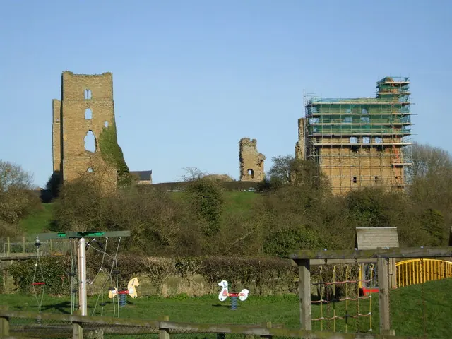
- Sheriff Hutton Castle - 0.49 km
Grade II
- Tomb to Atlay Family in Churchyard Approximately 10 Metres to South of South Chapel of Church of St Helen and Holy Cross - 0.25 km
- The Rangers House - 1.03 km
- Ice House Beneath Outbuildings to North of Sheriff Hutton Hall - 1.04 km
- Lion Statue in Grounds of Sheriff Hall Approximately 20 Metres East of House - 1.05 km
- Gate piers and urns at south-west entrance to garden of Sheriff Hutton Hall - 1.06 km
- Pedestal Carrying Urn at North-west End of North-east Garden Wall of Sheriff Hutton Hall - 1.06 km
- Pedestal and Urn in Grounds of Sheriff Hutton Hall Approximately 40 Metres South-east of House - 1.09 km
- Two Lengths of Garden Wall in Grounds of Sheriff Hutton Hall Extending Approximately 60 Metres South East of House - 1.1 km
- Second Amorini Statue Approximately 70 Metres South-east of Sheriff Hutton Hall - 1.12 km
- First Amorini Statue Approximately 70 Metres South of Sheriff Hutton Hall at End of Garden Wall - 1.13 km
- Gate Piers With Statues and Gates Approximately 100 Metres South-east of Sheriff Hutton Hall - 1.15 km
- Statue of Alexander Approximately 210 Metres South East of Sheriff Hutton Hall - 1.27 km
Scheduled Monuments Near Sheriff Hutton
Scheduled monuments are nationally important archaeological sites given legal protection. 2 lie within roughly a mile of Sheriff Hutton:
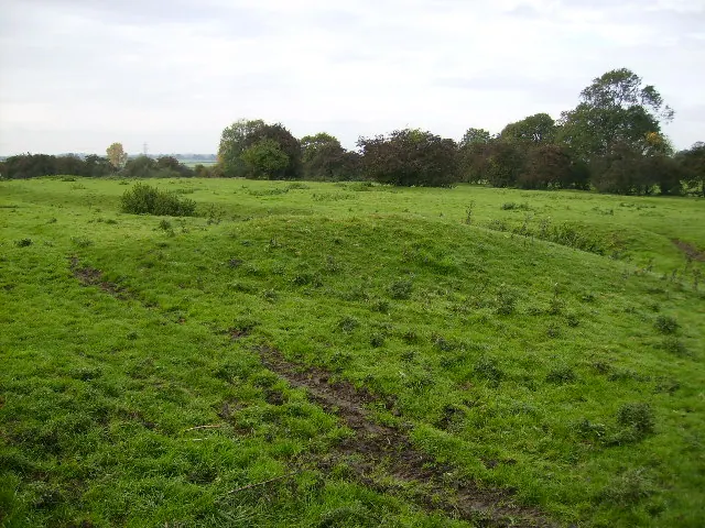
- Ringwork and bailey immediately south of St Helen and Holy Cross Church - 0.29 km
- Sheriff Hutton quadrangular castle and early garden earthworks - 0.66 km
Sheriff Hutton Today
Today Sheriff Hutton lies within the administrative area of Ryedale, and the settlement recorded a population of 1,059 at the 2021 census. Nine and a half centuries separate that figure from the small rural community the Domesday survey recorded here in 1086.
Read more about modern Sheriff Hutton on Wikipedia .
Nearby Domesday Settlements
Other places recorded in the 1086 survey within a few miles:
- West Lilling - 1.4 km SW
- Stittenham - 2.2 km NE
- Cornbrough House - 2.2 km NW
- Fornetorp - 2.2 km NW
- East Lilling - 2.2 km SE
- Thornton le Clay - 3.2 km E
Heritage Around [Sheriff] Hutton
Photographs of churches, listed buildings and monuments in the vicinity, contributed by volunteers to the Geograph project and reused here under a Creative Commons licence.
© Matthew Hatton · Geograph · CC BY-SA 2.0
© Phil Catterall · Geograph · CC BY-SA 2.0
© Phil Catterall · Geograph · CC BY-SA 2.0
Images © their respective photographers, licensed under CC BY-SA 2.0 and reused here with attribution. Photographs depict listed buildings, churches and monuments near this settlement and may show neighbouring villages.
Data derived from the Open Domesday project (opendomesday.org), based on the Domesday Book dataset compiled by Professor J.J.N. Palmer and team. The Domesday Book (1086) is in the public domain.
Found an inaccuracy? [email protected]