Saxton in the Domesday Book (1086)
Saxton is named in the Domesday Book, compiled by Norman commissioners in 1086, entered under the hundred of Barkston in Yorkshire.
Other Settlements in Barkston
- Barkston
- Barlow
- Birkin
- Bramham
- Brayton
- Burton [Hall]
- Camblesforth
- Carlton
- Clifford
- Drax
- Fairburn
- Grimston [Grange]
- Hambleton
- Hazelwood [Castle]
The Meaning of the Name
The name Saxton is of Anglo-Saxon origin. Its final element derives from the Old English word tūn, a farmstead or village. The first element is most likely a personal name or an early descriptive term, now difficult to recover with certainty. Taken together the name probably meant something close to ‘a farmstead’.
Remarkably, the name has changed little since 1086, when the Domesday scribes wrote it as Saxton.
Listed Buildings Near Saxton
Historic England records 10 listed buildings within about a mile of Saxton. Listing protects structures of special architectural or historic interest, graded I (exceptional), II* (particularly important) and II.
Grade I
- Church of All Saints - 0.41 km
Grade II*
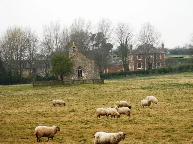
- Chapel of St Mary - 1.25 km
Grade II
- Village Farm - 0.31 km
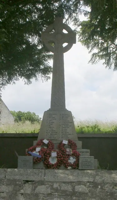
- Cross Shaft at All Saints Churchyard Approximately 5 Metres to East of Church - 0.41 km
- Lord Dacre’s Tomb Approximately 3 Metres to North of Church of All Saints - 0.43 km
- School Farm - 0.45 km
- White Rose Farm - 0.45 km
- Pigeoncote to School Farm Approximately 5 Metres to North of House - 0.46 km
- K6 Telephone Kiosk - 0.46 km
- Milestone Approimately 500 Metres South of Junction With Scarthingwell Lane - 1.25 km
Scheduled Monuments Near Saxton
Scheduled monuments are nationally important archaeological sites given legal protection. 2 lie within roughly a mile of Saxton:
- Saxton Castle: a motte and bailey castle with a later medieval manor house and field system including a trackway and fishpond - 0.24 km
- Medieval manorial complex, garden and water management features, St Mary’s chapel, and a linear earthwork forming part of the Aberford Dyke system - 1.36 km
Saxton Today
Today Saxton lies within the administrative area of Saxton with Scarthingwell.
Read more about modern Saxton on Wikipedia .
Nearby Domesday Settlements
Other places recorded in the 1086 survey within a few miles:
- Lead - 1.0 km W
- Barkston - 2.0 km E
- Towton - 3.2 km N
- Hunchilhuse - 3.2 km S
- Hunchilhuses - 3.2 km S
- Sherburn in Elmet - 3.2 km S
Heritage Around Saxton
Photographs of churches, listed buildings and monuments in the vicinity, contributed by volunteers to the Geograph project and reused here under a Creative Commons licence.

© I Love Colour · Geograph · CC BY-SA 2.0
© Betty Longbottom · Geograph · CC BY-SA 2.0
© SMJ · Geograph · CC BY-SA 2.0
Images © their respective photographers, licensed under CC BY-SA 2.0 and reused here with attribution. Photographs depict listed buildings, churches and monuments near this settlement and may show neighbouring villages.
Data derived from the Open Domesday project (opendomesday.org), based on the Domesday Book dataset compiled by Professor J.J.N. Palmer and team. The Domesday Book (1086) is in the public domain.
Found an inaccuracy? [email protected]