Sandal Magna in the Domesday Book (1086)
The settlement of Sandal Magna is recorded in William I’s Domesday survey of 1086, entered under the hundred of Agbrigg in Yorkshire.
Other Settlements in Agbrigg
- Ackton
- Almondbury
- Austonley
- Bradley
- Cartworth
- Crigglestone
- Crofton
- Dalton
- Emley
- Farnley [Tyas]
- Flockton
- Fulstone
- Golcar
- Hepworth
The Meaning of the Name
The origin of the name Sandal Magna is not securely established from its modern form alone; like many settlement names in the North it likely combines an Old English or Old Norse personal name with a landscape term.
Remarkably, the name has changed little since 1086, when the Domesday scribes wrote it as Sandal Magna.
Listed Buildings Near Sandal Magna
Historic England records 27 listed buildings within about a mile of Sandal Magna. Listing protects structures of special architectural or historic interest, graded I (exceptional), II* (particularly important) and II.
Grade II*
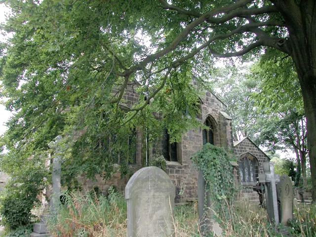
- Church of St Helen - 0.35 km
- Sandal Castle - 0.93 km
Grade II
- Sandal Vicarage - 0.37 km
- 6, Agbrigg Road - 0.39 km
- 4, Agbrigg Road - 0.39 km
- 2, Agbrigg Road - 0.4 km
- Gate Piers and Gates to West of Church of St Helen - 0.41 km
- Sandal House - 0.41 km
- 1, Shaw Fold - 0.42 km
- 7 and 9, Woodcroft - 0.42 km
- Alcove Immediately East of Number 236 - 0.42 km
- Outbuilding to South of Number 274 - 0.43 km
- Barleywood House - 0.43 km
- 3 and 5, Shaw Fold - 0.43 km
- Garden Wall to South West of Numbers 3 and 5 - 0.44 km
- Stable building to north of number 17 - 0.52 km
- Orchard Cottage - 0.61 km
- Castle Mount - 0.73 km
- Monument to Battle of Wakefield to East of Manygates School - 0.74 km
- Sandal Grange Farmhouse and Adjoining Farm Buildings - 0.78 km
- 220, Doncaster Road - 0.83 km
- 240, 242 (The Old Blacksmiths Shop), Mill and Cottage Doncaster Road - 0.86 km
- The Three Houses Inn - 1.01 km
- Elmwood House - 1.11 km
…and 3 more listed structures in the area.
Scheduled Monuments Near Sandal Magna
Scheduled monuments are nationally important archaeological sites given legal protection. 1 lies within roughly a mile of Sandal Magna:
Sandal Magna Today
Today Sandal Magna lies within the administrative area of Wakefield, and the settlement recorded a population of 5,432 at recent figures. Nine and a half centuries separate that figure from the small rural community the Domesday survey recorded here in 1086.
Read more about modern Sandal Magna on Wikipedia .
Nearby Domesday Settlements
Other places recorded in the 1086 survey within a few miles:
Heritage Around Sandal [Magna]
Photographs of churches, listed buildings and monuments in the vicinity, contributed by volunteers to the Geograph project and reused here under a Creative Commons licence.

© Martyn Pattison · Geograph · CC BY-SA 2.0
© Dennis Turner · Geograph · CC BY-SA 2.0
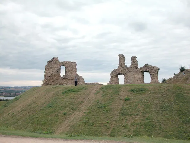
© Dennis Turner · Geograph · CC BY-SA 2.0
Images © their respective photographers, licensed under CC BY-SA 2.0 and reused here with attribution. Photographs depict listed buildings, churches and monuments near this settlement and may show neighbouring villages.
Data derived from the Open Domesday project (opendomesday.org), based on the Domesday Book dataset compiled by Professor J.J.N. Palmer and team. The Domesday Book (1086) is in the public domain.
Found an inaccuracy? [email protected]