Risley in the Domesday Book (1086)
The 1086 Domesday survey records the settlement of Risley, entered under the hundred of Morleystone in Derbyshire. The survey assessed Risley at 1.1 carucates of taxable land.
The survey records Risley’s value at 1 shilling in 1086. No pre-Conquest figure survives – not unusual in the North, where records were disrupted by the Harrying and by the patchy coverage of the survey.
Resources Recorded at Risley (1086)
- Woodland: 20 pigs
Other Settlements in Morleystone
- Bradley
- Breadsall
- Breaston
- Cellesdene
- Chaddesden
- Codnor
- Crich
- Denby
- Derby
- Draycott
- Duffield
- Hallam
- Heanor
- Herdebi
The Meaning of the Name
The name Risley is of Anglo-Saxon origin. Its final element derives from the Old English word lēah, a woodland clearing or glade. The first element is most likely a personal name or an early descriptive term, now difficult to recover with certainty. Taken together the name probably meant something close to ‘a clearing’.
Remarkably, the name has changed little since 1086, when the Domesday scribes wrote it as Risley.
Listed Buildings Near Risley
Historic England records 18 listed buildings within about a mile of Risley. Listing protects structures of special architectural or historic interest, graded I (exceptional), II* (particularly important) and II.
Grade II*
- Latin College and the Latin Cottage - 0.5 km
- The Old School House - 0.5 km
- Latin House - 0.52 km
- Balustrades, Gateway and Bridge on Terrace to South East of Risley Hall - 0.53 km
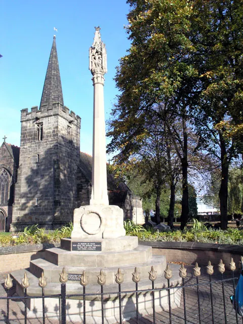
- Church of All Saints - 0.55 km
Grade II
- Bobbin Milepost East of Risley Grammar School (Sk 4635 3574) - 0.4 km
- Risleyhall Farmhouse and Attached Barn - 0.48 km
- Walls to Front of the Latin House and Latin College - 0.48 km
- The Grammar School - 0.48 km
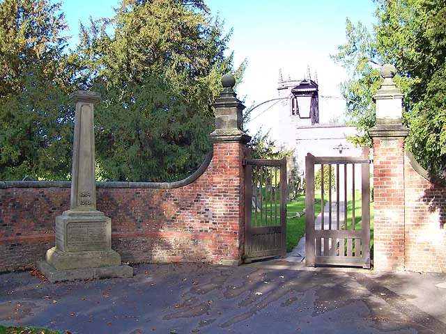
- Churchyard Walls, Gates and War Memorial to South of All Saints Church - 0.54 km
- Pair of Chest Tombs 15 Metres South of South Door to All Saints Church - 0.54 km
- Church Cottage - 0.56 km
- Garden Walls and Gateway to North of Risley Hall - 0.58 km
- Pair of Matching Urns to East of Garden Front of Risley Hall - 0.59 km
- Brook House - 0.59 km
- Risley Hall and Attached Garden Wall - 0.6 km
- Dr Bland’s Almshouses - 1.26 km
- Dr Bland’s Almshouses - 1.28 km
Risley Today
Today Risley lies within the administrative area of Erewash, and the settlement recorded a population of 735 at the 2021 census. Nine and a half centuries separate that figure from the small rural community the Domesday survey recorded here in 1086.
Read more about modern Risley on Wikipedia .
Nearby Domesday Settlements
Other places recorded in the 1086 survey within a few miles:
- Sandiacre - 1.4 km NE
- Stanton -by-Dale - 2.0 km N
- Hopwell - 2.2 km NW
- Breaston - 2.2 km SW
- Draycott - 2.8 km SW
- Long Eaton - 3.6 km SE
Heritage Around Risley
Photographs of churches, listed buildings and monuments in the vicinity, contributed by volunteers to the Geograph project and reused here under a Creative Commons licence.
© Garth Newton · Geograph · CC BY-SA 2.0
© David Lally · Geograph · CC BY-SA 2.0
© Dave Bevis · Geograph · CC BY-SA 2.0
Images © their respective photographers, licensed under CC BY-SA 2.0 and reused here with attribution. Photographs depict listed buildings, churches and monuments near this settlement and may show neighbouring villages.
Data derived from the Open Domesday project (opendomesday.org), based on the Domesday Book dataset compiled by Professor J.J.N. Palmer and team. The Domesday Book (1086) is in the public domain.
Found an inaccuracy? [email protected]