Ravensworth in the Domesday Book (1086)
Ravensworth appears in the Domesday Book of 1086, entered under the hundred of Land of Count Alan in Yorkshire. The survey assessed Ravensworth at 20 carucates of taxable land.
At the time of the survey, Ravensworth supported a recorded population of 42 villagers, 79 smallholders, 31 slaves, working 36 ploughs between them.
The survey records Ravensworth’s value at 40.5 shillings in 1086. No pre-Conquest figure survives – not unusual in the North, where records were disrupted by the Harrying and by the patchy coverage of the survey.
Resources Recorded at Ravensworth (1086)
- Mills: 6 mills (valued at 1.03 shillings)
- Cattle: 35
- Pigs: 56
- Sheep: 500
- Horses (cobs): 4
- Meadow: 132.5 acres
- Woodland: 1 * 0.5 and 46 acres mixed measures
Other Settlements in Land of Count Alan
- Achebi
- Agglethorpe
- Ainderby [Mires]
- Ainderby [Quernhow]
- Aiskew
- Aldbrough
- Allerthorpe [Hall]
- Ascam
- Ascham
- Asebi
- Aske [Hall]
- Askrigg
- Aysgarth
- Baldersby
The Meaning of the Name
The name Ravensworth is of Anglo-Saxon origin. Its final element derives from the Old English word worð, an enclosure or homestead. The first element is most likely a personal name or an early descriptive term, now difficult to recover with certainty. Taken together the name probably meant something close to ‘a enclosure’.
Remarkably, the name has changed little since 1086, when the Domesday scribes wrote it as Ravensworth.
Listed Buildings Near Ravensworth
Historic England records 45 listed buildings within about a mile of Ravensworth. Listing protects structures of special architectural or historic interest, graded I (exceptional), II* (particularly important) and II.
Grade I
- Ravensworth Castle and Park Wall - 0.44 km
Grade II
- Cart-shed Approximately 5 Metres to North of Tofta House - 0.45 km
- Tofta House - 0.47 km
- Pound - 0.51 km
- Village Hall - 0.61 km
- Numbers 41 and 43 (West View Cottage) - 0.62 km
- 39, the Green - 0.65 km
- Cross Base - 0.66 km
- 30, the Green - 0.66 km
- 28, the Green - 0.67 km
- Number 26, the Green - 0.68 km
- Walls and Railings to Front Gardens of Numbers 24, 26 and 28 - 0.68 km
- Park Farmhouse - 0.68 km
- 24, the Green - 0.69 km
- Park House - 0.7 km
- Number 20, With Attached Outbuilding to Left - 0.72 km
- Coach-house Approximately 30 Metres West of Park House - 0.73 km
- Enclosure For Livestock Accommodation, Possibly For Waterfowl - 0.75 km
- Ash Cottage With Attached Outbuilding to Right - 0.79 km
- Cowhouse, Approximately 15 Metres West of Park House - 0.79 km
- Holme Bridge Over Holme Beck - 0.81 km
- Sunset Cottage - 0.82 km
- Mill Farmhouse Cottage - 0.84 km
- Mill Farmhouse and Front Garden Wall - 0.86 km
…and 21 more listed structures in the area.
Scheduled Monuments Near Ravensworth
Scheduled monuments are nationally important archaeological sites given legal protection. 1 lies within roughly a mile of Ravensworth:
- Ravensworth motte and bailey castle, water defence features, park pale and shrunken medieval village - 0.5 km
Ravensworth Today
Today Ravensworth lies within the administrative area of Richmondshire, and the settlement recorded a population of 233 at the 2021 census. Nine and a half centuries separate that figure from the small rural community the Domesday survey recorded here in 1086.
Read more about modern Ravensworth on Wikipedia .
Nearby Domesday Settlements
Other places recorded in the 1086 survey within a few miles:
- West Layton - 2.0 km N
- East Layton - 2.8 km NE
- Dalton - 3.2 km W
- Dalton - 3.2 km W
- Hartforth - 3.2 km E
- Didderston Grange - 4.0 km E
Heritage Around Ravensworth
Photographs of churches, listed buildings and monuments in the vicinity, contributed by volunteers to the Geograph project and reused here under a Creative Commons licence.
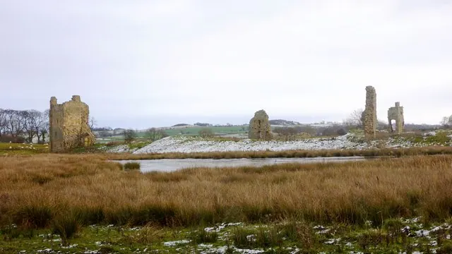
© Andy Waddington · Geograph · CC BY-SA 2.0
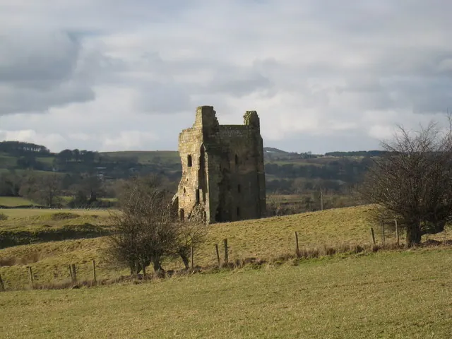
© Philip Barker · Geograph · CC BY-SA 2.0
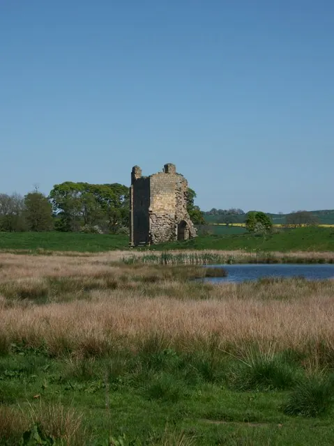
© Matthew Hatton · Geograph · CC BY-SA 2.0
Images © their respective photographers, licensed under CC BY-SA 2.0 and reused here with attribution. Photographs depict listed buildings, churches and monuments near this settlement and may show neighbouring villages.
Location
54.4625°N, -1.7763°W · Land of Count Alan hundred, Yorkshire
View larger map on OpenStreetMap →Data derived from the Open Domesday project (opendomesday.org), based on the Domesday Book dataset compiled by Professor J.J.N. Palmer and team. The Domesday Book (1086) is in the public domain.
Found an inaccuracy? [email protected]