Parlington in the Domesday Book (1086)
Parlington is named in the Domesday Book, compiled by Norman commissioners in 1086, entered under the hundred of Skyrack in Yorkshire. The survey assessed Parlington at 1 carucate of taxable land.
Parlington is recorded as waste in the 1086 survey. The waste designation appears to predate the Norman Conquest - suggesting the settlement had already been struggling before 1066, though the subsequent Harrying of the North in 1069–70 would have made recovery significantly harder.
Other Settlements in Skyrack
- Adel
- Allerton [Bywater]
- Alwoodley
- Arthington
- Austhorpe
- Baildon
- Bardsey
- Barwick [in Elmet]
- Bichertun
- Bicherun
- Bingley
- Birkby [Hill]
- Bramhope
- Burden [Head]
The Meaning of the Name
The name Parlington is of Anglo-Saxon origin. Its final element derives from the Old English word tūn, a farmstead or village. The first element is most likely a personal name or an early descriptive term, now difficult to recover with certainty. Taken together the name probably meant something close to ‘a farmstead’.
Remarkably, the name has changed little since 1086, when the Domesday scribes wrote it as Parlington.
Listed Buildings Near Parlington
Historic England records 36 listed buildings within about a mile of Parlington. Listing protects structures of special architectural or historic interest, graded I (exceptional), II* (particularly important) and II.
Grade II*
- Triumphal Arch - 0.43 km
- Gascoigne Almshouses and Attached Wardens Cottage - 0.64 km
Grade II
- Shelter at Approximately Se428368 - 0.21 km
- The Light Arch - 0.22 km
- Icehouse situated in the Wilderness to the east of the former kitchen garden, Parlington Estate - 0.33 km
- The Gardens House With Attached Hot Walls, Walls of the Former Walled Garden, and Wall Enclosing Semi-circular Garden to North-west - 0.5 km
- The Cottage - 0.52 km
- The Dark Arch - 0.57 km
- Pump approximately 10 metres to rear of Gascoigne Almshouses - 0.63 km
- Lodge to Gascoigne Almshouses - 0.7 km
- Front Wall to Grounds of Gascoigne Almshouses With Gatepiers at Each End - 0.71 km
- Milepost Against Wall of Garden to St Wilfrids Roman Catholic Church - 0.72 km
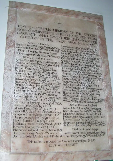
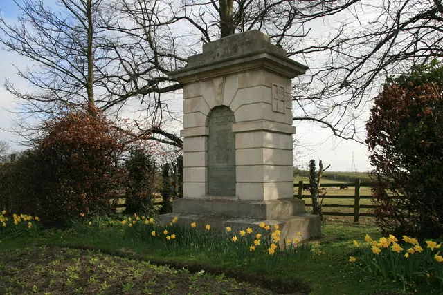
- Aberford War Memorial - 0.73 km
- Stallion pens to the north-east of Home Farm, Parlington Estate - 0.74 km
- Roman Catholic Church of St Wilfrid With Attached Presbytery - 0.77 km
- Parlington Home Farm, including farmhouse and farm buildings - 0.78 km
- Hicklam House - 0.8 km
- Church House - 0.92 km
- Pikes Head Lodge - 0.94 km
- Manor Farm Cottage and 1 and 2 Coach House - 0.94 km
- Parish Church of St Ricarius or St Riquier - 0.96 km
- Market Cross Beside South Gate to Church of St Ricarius - 0.97 km
- Stable Block to Rear of Swan Hotel - 1.0 km
- Hicklam Mill - 1.01 km
…and 12 more listed structures in the area.
Scheduled Monuments Near Parlington
Scheduled monuments are nationally important archaeological sites given legal protection. 3 lie within roughly a mile of Parlington:
- Iron Age and Romano-British Settlement south of Hungerhills Plantation, Parlington - 0.43 km
- Length of linear earthwork, part of the Aberford Dyke system, at Green Hill between Aberford and the Aberford By-pass - 1.49 km
- Length of linear earthworks known as Becca Banks and The Ridge, part of the Aberford Dyke system, between Aberford and a quarry 590m north of Ass Bridge - 1.54 km
Parlington Today
Today Parlington lies within the administrative area of Leeds, and the settlement recorded a population of 93 at the 2021 census. Nine and a half centuries separate that figure from the small rural community the Domesday survey recorded here in 1086.
Read more about modern Parlington on Wikipedia .
Nearby Domesday Settlements
Other places recorded in the 1086 survey within a few miles:
- Potterton - 2.8 km NW
- Cowthwaite - 3.0 km N
- Sturton Grange - 3.0 km S
- Barwick in Elmet - 3.2 km W
- Hazelwood Castle - 3.6 km NE
- Garforth - 3.6 km SW
Heritage Around Parlington
Photographs of churches, listed buildings and monuments in the vicinity, contributed by volunteers to the Geograph project and reused here under a Creative Commons licence.
© vernon wood · Geograph · CC BY-SA 2.0
© John Readman · Geograph · CC BY-SA 2.0
© David Rogers · Geograph · CC BY-SA 2.0
Images © their respective photographers, licensed under CC BY-SA 2.0 and reused here with attribution. Photographs depict listed buildings, churches and monuments near this settlement and may show neighbouring villages.
Data derived from the Open Domesday project (opendomesday.org), based on the Domesday Book dataset compiled by Professor J.J.N. Palmer and team. The Domesday Book (1086) is in the public domain.
Found an inaccuracy? [email protected]