Newton in the Domesday Book (1086)
The 1086 Domesday survey records the settlement of Newton, entered under the hundred of Middlewich in Cheshire. The survey assessed Newton at 5 carucates of taxable land.
At the time of the survey, Newton supported a recorded population of 2 villagers, 1 smallholder, working 2 ploughs between them.
The drop in value is hard to miss. Before 1066, Newton was worth 1.5 shillings; by 1086 that had dropped to 1.05 shillings – a fall of 29%. Most Yorkshire villages that lost value on this scale were swept up in the Harrying of the North – William’s scorched-earth campaign of 1069–70.
Resources Recorded at Newton (1086)
- Mills: 1 mill (valued at 8d)
Other Settlements in Middlewich
- Alsager
- Bostock
- Brereton
- Byley
- Clive
- Congleton
- Croxton
- Davenham
- Davenport
- Goostrey
- Hassall
- Kinderton
- Lach [Dennis]
- Leftwich
The Meaning of the Name
The name Newton is of Anglo-Saxon origin. Its final element derives from the Old English word tūn, a farmstead or village, while the first element appears to represent the new. Taken together the name probably meant something close to ’the new farmstead’.
Remarkably, the name has changed little since 1086, when the Domesday scribes wrote it as Newton.
Listed Buildings Near Newton
Historic England records 36 listed buildings within about a mile of Newton. Listing protects structures of special architectural or historic interest, graded I (exceptional), II* (particularly important) and II.
Grade II*
- 64, St Ann’s Road - 0.7 km
- Church of St Michael and All Angels - 0.81 km
Grade II
- Trent and Mersey Canal King’s Lock - 0.17 km
- Trent and Mersey Canal Bridge Number 167 - 0.19 km
- Middlewich Branch of Shropshire Union Canal Lock-keeper’s Cottage - 0.23 km
- Middlewich Branch of Shropshire Union Canal Canal Lock Adjacent to Junction With Trent and Mersey Canal - 0.24 km
- Trent and Mersey Canal Bridge Number 168 - 0.25 km
- Middlewich Branch of Shropshire Union Canal Bridge Number 31 Carrying Sutton Lane Over Canal - 0.27 km
- Middlewich Branch of Shropshire Union Canal Bridge Number 30 Carrying St Ann’s Road Over Canal - 0.33 km
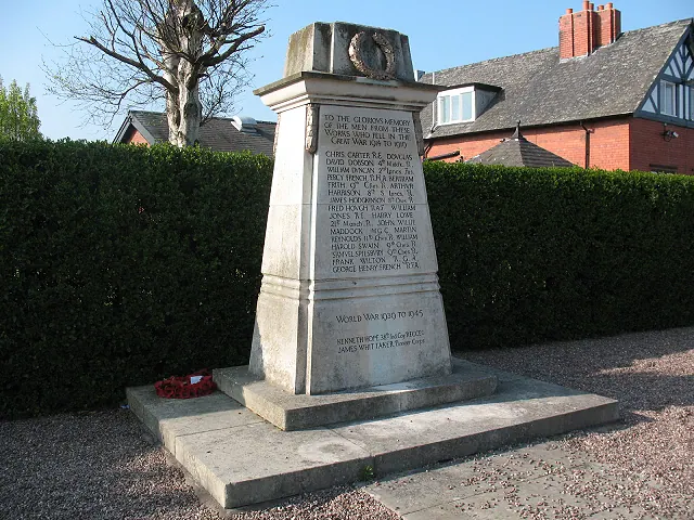
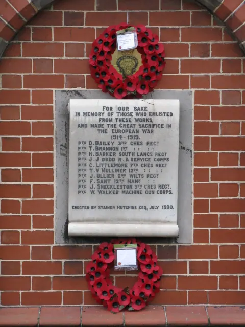
- Brunner Mond Middlewich War Memorial - 0.39 km
- Trent and Mersey Canal, Canal Milepost at Ngr 7064 6585 - 0.41 km
- Canal Stables and Sawpit House - 0.42 km
- Trent and Mersey Canal, House and Attached Canal Office - 0.42 km
- 33 and 33A, Lewin Street - 0.59 km
- Trent and Mersey Canal, Three Locks and Two Intermediate Basins, With Dry Dock Off Upper Basin - 0.61 km
- Middlewich Branch of Shropshire Union Canal Bridge Number 28 Carrying Footpath Over Canal - 0.64 km
- 66, St Ann’s Road - 0.69 km
- 62, St Ann’s Road - 0.72 km
- 25, Queen Street - 0.73 km
- Newton Hall - 0.76 km
- Newton Old Hall - 0.77 km
- Manor House - 0.77 km
- Well in Rear Garden of Number 3 (Newton Old Hall) - 0.78 km
- Sundial South of West Bay of Church of St Michael and All Angels - 0.79 km
…and 12 more listed structures in the area.
Scheduled Monuments Near Newton
Scheduled monuments are nationally important archaeological sites given legal protection. 3 lie within roughly a mile of Newton:
- Murgatroyd’s Brine Works - 0.62 km
- King Street Roman fort, Harbutt’s Field - 1.53 km
- Kinderton Hall moated site, two annexes, five fishponds, garden and prospect mound - 1.57 km
Newton Today
Today Newton lies within the administrative area of Middlewich.
Nearby Domesday Settlements
Other places recorded in the 1086 survey within a few miles:
Heritage Around Newton
Photographs of churches, listed buildings and monuments in the vicinity, contributed by volunteers to the Geograph project and reused here under a Creative Commons licence.
© Stephen Craven · Geograph · CC BY-SA 2.0
© Peter Whatley · Geograph · CC BY-SA 2.0
© Stephen Craven · Geograph · CC BY-SA 2.0
Images © their respective photographers, licensed under CC BY-SA 2.0 and reused here with attribution. Photographs depict listed buildings, churches and monuments near this settlement and may show neighbouring villages.
Data derived from the Open Domesday project (opendomesday.org), based on the Domesday Book dataset compiled by Professor J.J.N. Palmer and team. The Domesday Book (1086) is in the public domain.
Found an inaccuracy? [email protected]