Melling in the Domesday Book (1086)
The 1086 Domesday survey records the settlement of Melling, entered under the hundred of Amounderness in Yorkshire. The survey assessed Melling at 4 carucates of taxable land.
At the time of the survey, Melling supported a recorded population of 15 villagers, 6 smallholders, 11 slaves, working 10 ploughs between them.
By 1086 Melling was worth 24 shillings, up from 20 shillings before the Conquest – which sets it apart from the many nearby villages left waste or devalued.
Resources Recorded at Melling (1086)
- Mills: 2 mills (valued at 14d)
- Churches: 1
- Woodland: 40 swine render
Other Settlements in Amounderness
- Aighton
- Aldcliffe
- Aldingham
- Arkholme
- Aschebi
- Ashton [Hall]
- Ashton [on Ribble]
- Austwick
- Barbon
- Bardsea
- Bare
- Barnoldswick
- Barton
- Beetham
The Meaning of the Name
The origin of the name Melling is not securely established from its modern form alone; like many settlement names in the North it likely combines an Old English or Old Norse personal name with a landscape term.
Remarkably, the name has changed little since 1086, when the Domesday scribes wrote it as Melling.
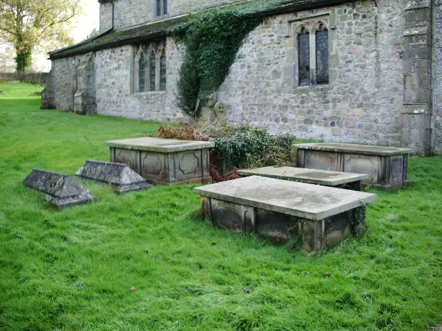
Listed Buildings Near Melling
Historic England records 32 listed buildings within about a mile of Melling. Listing protects structures of special architectural or historic interest, graded I (exceptional), II* (particularly important) and II.
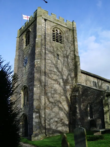
Grade I
- Church of St Wilfrid - 0.39 km
Grade II*
- The Old Malt House - 0.49 km
- Church of St John the Baptist - 0.76 km
Grade II
- Todd’s House - 0.34 km
- Crowtrees Farmhouse and Barn Adjoining to South-west - 0.34 km
- Milestone - 0.35 km
- Melling Hall Hotel - 0.35 km
- Milestone - 0.35 km
- Churchyard Wall Bordering Main Street, With Steps at North and South Ends, and Gate Piers at South End - 0.36 km
- Church Gates Cottage and Barn Adjoining to North - 0.37 km
- Vicarage - 0.39 km
- Hodgson Tomb Approx. 7 Metres East of Church of St Wilfrid - 0.39 km
- Church Gate - 0.39 km
- Sundial South of Church of St Wilfrid - 0.4 km
- The Barn - 0.45 km
- Crow Trees - 0.46 km
- Old Crowtrees - 0.5 km
- Cross Base, Approximately 2 Metres South of Church of St John the Baptist - 0.76 km
- Lune Cottage - 0.8 km
- Village Pound - 0.81 km
- Chapel House - 0.84 km
- Cross House - 0.84 km
- Cawood House - 0.97 km
- Cringleber Farmhouse - 0.98 km
…and 8 more listed structures in the area.
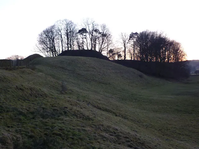
Scheduled Monuments Near Melling
Scheduled monuments are nationally important archaeological sites given legal protection. 2 lie within roughly a mile of Melling:
- Castle Mound motte and bailey, Melling - 0.42 km
- Chapel Hill Motte, Arkholme - 0.75 km
Melling Today
Today Melling lies within the administrative area of Melling-with-Wrayton.
Read more about modern Melling on Wikipedia .
Nearby Domesday Settlements
Other places recorded in the 1086 survey within a few miles:
- Arkholme - 1.4 km NW
- Wennington - 2.2 km SE
- Tatham - 2.2 km SE
- Tunstall - 2.2 km NE
- Gressingham - 2.8 km SW
- Newton - 3.0 km N
Heritage Around Melling
Photographs of churches, listed buildings and monuments in the vicinity, contributed by volunteers to the Geograph project and reused here under a Creative Commons licence.
© Karl and Ali · Geograph · CC BY-SA 2.0
© Alexander P Kapp · Geograph · CC BY-SA 2.0
© Alexander P Kapp · Geograph · CC BY-SA 2.0
Images © their respective photographers, licensed under CC BY-SA 2.0 and reused here with attribution. Photographs depict listed buildings, churches and monuments near this settlement and may show neighbouring villages.
Data derived from the Open Domesday project (opendomesday.org), based on the Domesday Book dataset compiled by Professor J.J.N. Palmer and team. The Domesday Book (1086) is in the public domain.
Found an inaccuracy? [email protected]