Mapleton in the Domesday Book (1086)
Mapleton appears in the Domesday Book of 1086, entered under the hundred of Hamston in Derbyshire. The survey assessed Mapleton at 10.0 carucates of taxable land.
At the time of the survey, Mapleton supported a recorded population of 7 villagers, 3 smallholders, 2 slaves, working 8 ploughs between them.
The numbers record a sharp fall. Before 1066, Mapleton was worth 5.64 shillings; by 1086 that had dropped to 5.54 shillings – a fall of 1%. Most Yorkshire villages that lost value on this scale were swept up in the Harrying of the North – William’s scorched-earth campaign of 1069–70.
The survey lists 8 manors at Mapleton under different lords. Splitting a single settlement between multiple tenants was common across the North – Saxon estates broken up and handed to William’s followers after 1066.
Resources Recorded at Mapleton (1086)
- Meadow: 1 ploughs
- Woodland: 100 pigs
Other Settlements in Hamston
- Alsop [-en-le-Dale]
- Ashbourne
- Atlow
- Ballidon
- Bonsall
- Bradbourne
- Brassington
- Broadlowash
- Callow
- Carsington
- Cowley
- Cromford
- Elton
- Hanson [Grange]
The Meaning of the Name
The name Mapleton is of Anglo-Saxon origin. Its final element derives from the Old English word tūn, a farmstead or village. The first element is most likely a personal name or an early descriptive term, now difficult to recover with certainty. Taken together the name probably meant something close to ‘a farmstead’.
Remarkably, the name has changed little since 1086, when the Domesday scribes wrote it as Mapleton.
Listed Buildings Near Mapleton
Historic England records 32 listed buildings within about a mile of Mapleton. Listing protects structures of special architectural or historic interest, graded I (exceptional), II* (particularly important) and II.
Grade II*
- Manor House - 0.27 km
- Church of St Mary - 0.58 km
- Okeover Almshouses - 0.64 km
- Outer Gates and Gate Piers to Okeover Hall - 0.84 km
- Church of All Saints - 1.0 km
- Inner Gate Piers, Gates and Railings to Okeover Hall - 1.01 km
- Gates, Piers and Railings Immediately North East of Okeover Hall - 1.02 km
- Okeover Hall - 1.03 km
- Statue, Sundial and Steps Approximately 30 Yards North of Okeover Hall - 1.04 km
- Gates and Railings Enclosing South Side of Garden to West of Okeover Hall - 1.11 km
Grade II
- Mill House - 0.34 km
- Callow Hall - 0.54 km
- Okeover Arms Public House - 0.55 km
- Stables to Callow Hall - 0.61 km
- Okeover Bridge - 0.7 km
- Okeover Bridge (That Part in Staffordshire) - 0.7 km
- Okeover Mill - 0.84 km
- Haywood Farmhouse - 0.88 km
- Gate Piers at Hinchleywood - 0.9 km
- Hinchleywood - 0.99 km
- Stables Approximately 50 Yards North East of Okeover Hall - 1.03 km
- Statue at Ngr Sk 1574 4811 - 1.07 km
- Statue at Ngr Sk 1572 4811 - 1.09 km
- Statue at Ngr Sk 1573 4812 - 1.09 km
…and 8 more listed structures in the area.
Scheduled Monuments Near Mapleton
Scheduled monuments are nationally important archaeological sites given legal protection. 1 lies within roughly a mile of Mapleton:
Mapleton Today
Today Mapleton lies within the administrative area of Derbyshire Dales, and the settlement recorded a population of 132 at the 2021 census. Nine and a half centuries separate that figure from the small rural community the Domesday survey recorded here in 1086.
Read more about modern Mapleton on Wikipedia .
Nearby Domesday Settlements
Other places recorded in the 1086 survey within a few miles:
- Ashbourne - 2.2 km SE
- Clifton - 3.0 km S
- Offcote - 3.2 km E
- Fenton - 3.2 km E
- Sturston Hall and Nether Sturston - 3.2 km E
- Fenny Bentley - 3.2 km N
Heritage Around Mapleton
Photographs of churches, listed buildings and monuments in the vicinity, contributed by volunteers to the Geograph project and reused here under a Creative Commons licence.
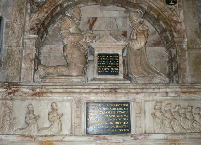
© Eirian Evans · Geograph · CC BY-SA 2.0
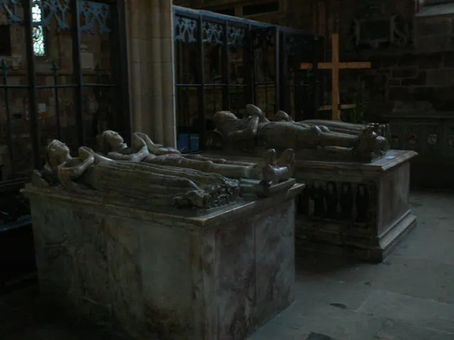
© Eirian Evans · Geograph · CC BY-SA 2.0
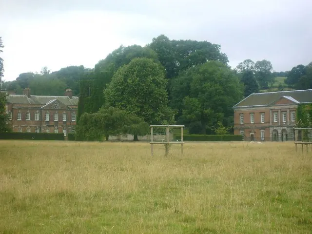
© Brian Ward · Geograph · CC BY-SA 2.0
Images © their respective photographers, licensed under CC BY-SA 2.0 and reused here with attribution. Photographs depict listed buildings, churches and monuments near this settlement and may show neighbouring villages.
Data derived from the Open Domesday project (opendomesday.org), based on the Domesday Book dataset compiled by Professor J.J.N. Palmer and team. The Domesday Book (1086) is in the public domain.
Found an inaccuracy? [email protected]