Malpas in the Domesday Book (1086)
The 1086 Domesday survey records the settlement of Malpas, entered under the hundred of Duddeston in Cheshire.
Other Settlements in Duddeston
- Bettisfield
- Bickerton
- Bickley
- Boughton
- Broxton
- Burwardestone
- Burwardsley and [Higher] Burwardsley
- Caldecott
- Calvintone
- Cheaveley
- Cholmondeley
- Chowley
- Christleton
- Clutton
The Meaning of the Name
The origin of the name Malpas is not securely established from its modern form alone; like many settlement names in the North it likely combines an Old English or Old Norse personal name with a landscape term.
Remarkably, the name has changed little since 1086, when the Domesday scribes wrote it as Malpas.
Listed Buildings Near Malpas
Historic England records 55 listed buildings within about a mile of Malpas. Listing protects structures of special architectural or historic interest, graded I (exceptional), II* (particularly important) and II.
Grade I
- Church of St Oswald - 0.28 km
Grade II
- Ivy Cottage - 0.06 km
- Woodville, With Walls to Yard to Right - 0.08 km
- The Old School House - 0.08 km
- Alport Cottage - 0.08 km
- Alport House - 0.09 km
- Prospect House - 0.1 km
- Chester Villa - 0.13 km
- Drake’s Cottage and Drakes House, With Walls to Front Gardens - 0.14 km
- Taylor’s Almshouses - 0.15 km
- Huxley’s and flat - 0.2 km
- 11, High Street - 0.21 km
- The Rectory - 0.22 km
- Rock House With Retaining Wall and Steps - 0.24 km
- 1, Church Street - 0.25 km
- Malpas Post Office - 0.25 km
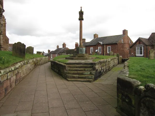
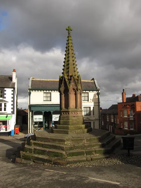
- Malpas Cross - 0.26 km
- Water Valve Housing on South East Side of the Cross - 0.27 km
- Churchyard Wall Between South East Gates and Motte - 0.27 km
- Tomb of John Bassett, Circa 8 Metres North of West Bay of Nave of Church of St Oswald - 0.27 km
- The Cross Pharmacy and House - 0.27 km
- K6 Telephone Kiosk by Lloyds Bank - 0.27 km
- The Wyvern - 0.27 km
- 3 and 5, Church Street - 0.28 km
…and 31 more listed structures in the area.
Scheduled Monuments Near Malpas
Scheduled monuments are nationally important archaeological sites given legal protection. 3 lie within roughly a mile of Malpas:
- Castle Hill motte, Malpas - 0.23 km
- Malpas cross at town centre junction of Church Street and Oldhall Street - 0.26 km
- Medieval and post-medieval settlement remains and associated field system immediately east of Overton Hall - 1.38 km
Malpas Today
Today Malpas lies within the administrative area of Cheshire West and Chester, and the settlement recorded a population of 2,503 at the 2021 census. Nine and a half centuries separate that figure from the small rural community the Domesday survey recorded here in 1086.
Read more about modern Malpas on Wikipedia .
Nearby Domesday Settlements
Other places recorded in the 1086 survey within a few miles:
- Overton - 1.4 km NW
- Hampton - 2.2 km NE
- Edge - 3.0 km N
- Tushingham - 4.1 km E
- Duckington - 4.1 km N
- Larkton - 4.5 km NE
Heritage Around Malpas
Photographs of churches, listed buildings and monuments in the vicinity, contributed by volunteers to the Geograph project and reused here under a Creative Commons licence.
© John S Turner · Geograph · CC BY-SA 2.0
© John S Turner · Geograph · CC BY-SA 2.0
© BrianPritchard · Geograph · CC BY-SA 2.0
Images © their respective photographers, licensed under CC BY-SA 2.0 and reused here with attribution. Photographs depict listed buildings, churches and monuments near this settlement and may show neighbouring villages.
Data derived from the Open Domesday project (opendomesday.org), based on the Domesday Book dataset compiled by Professor J.J.N. Palmer and team. The Domesday Book (1086) is in the public domain.
Found an inaccuracy? [email protected]