Kirkleatham in the Domesday Book (1086)
Kirkleatham appears in the Domesday Book of 1086, entered under the hundred of Langbaurgh in Yorkshire.
Other Settlements in Langbaurgh
- Acklam
- Airy [Holme]
- Aislaby
- Arnodestorp
- Baldebi
- Barnaby
- Barwick
- Battersby
- Bergolbi
- Berguluesbi
- Blaten [Carr]
- Borrowby
- Breck
- Brotton
The Meaning of the Name
The name Kirkleatham is of Anglo-Saxon origin. Its final element derives from the Old English word hām, a homestead or village, while the first element appears to represent the church (ON kirkja). Taken together the name probably meant something close to ’the church homestead’.
Remarkably, the name has changed little since 1086, when the Domesday scribes wrote it as Kirkleatham.
Listed Buildings Near Kirkleatham
Historic England records 35 listed buildings within about a mile of Kirkleatham. Listing protects structures of special architectural or historic interest, graded I (exceptional), II* (particularly important) and II.
Grade I
- Sir William Turner’s Hospital - 0.31 km
- Entrance Screen Loggias Forts Flat and Outhouses to Sir William Turners Hospital - 0.35 km
- Church of St Cuthbert - 0.39 km
- Turner Mausoleum Adjoining Church of St Cuthbert - 0.39 km
- Gatepiers at Entrance to Forecourt of Kirkleatham Hall School - 0.4 km
Grade II*
- Statue of Justice in Courtyard of Sir William Turners Hospital - 0.32 km
- Old Hall Museum - 0.41 km
- Kirkleatham Hall Farm - 0.44 km
- Gatehouse 120 Metres North East of Kirkleatham Hall Farm - 0.52 km
- Bastion 100 Metres North West of Kirkleatham Hall Farm - 0.56 km
Grade II
- Boundary Walls and Transverse Wall Enclosing Former Kirkleatham Gardens - 0.29 km
- Ha-ha Wall at Entrance to Sir William Turners Hospital - 0.35 km
- Boundary Wall Ha-ha Wall Gates and Gatepiers to South of Kirkleatham Hall School - 0.36 km
- The Cottages - 0.37 km
- Gates, Gatepiers, Wall Steps and Mounting Block East of Church of St Cuthbert - 0.37 km
- The Cottages no 8 (The Dower House) and Nos 9 and 10 - 0.37 km
- Corney Chest Tomb One Metre East of Church of St Cuthbert - 0.38 km
- The Cottages the Old Vicarage - 0.39 km
- Gatepiers at Entrance to Drive of Kirkleatham Hall School - 0.39 km
- Buttress With Coat of Arms Circa 2 Metres East of Turner Mausoleum - 0.39 km
- Turner’s Arms Farmhouse and Attached Wall - 0.39 km
- Newcomen Tombstone Circa 8 Metres North West of Church of St Cuthbert - 0.4 km
- Gaunt Tombstone Circa 10 Metres North of Church of St Cuthbert - 0.41 km
- Barn and Stable Adjoining Kirkleatham Hall Farm - 0.46 km
…and 11 more listed structures in the area.
Kirkleatham Today
Today Kirkleatham lies within the administrative area of Redcar and Cleveland, and the settlement recorded a population of 7,045 at recent figures. Nine and a half centuries separate that figure from the small rural community the Domesday survey recorded here in 1086.
Read more about modern Kirkleatham on Wikipedia .
Nearby Domesday Settlements
Other places recorded in the 1086 survey within a few miles:
- Wilton - 2.2 km SW
- Lazenby - 2.8 km SW
- Lackenby - 3.6 km SW
- Thornton Fields - 3.6 km SE
- Marske by the Sea - 4.1 km E
- Upleatham - 4.5 km SE
Heritage Around Kirkleatham
Photographs of churches, listed buildings and monuments in the vicinity, contributed by volunteers to the Geograph project and reused here under a Creative Commons licence.
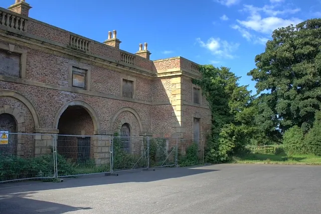
© Mick Garratt · Geograph · CC BY-SA 2.0
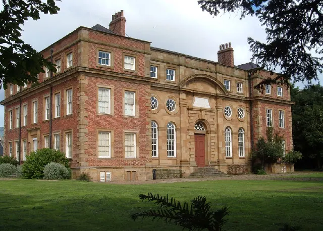
© Alison Stamp · Geograph · CC BY-SA 2.0
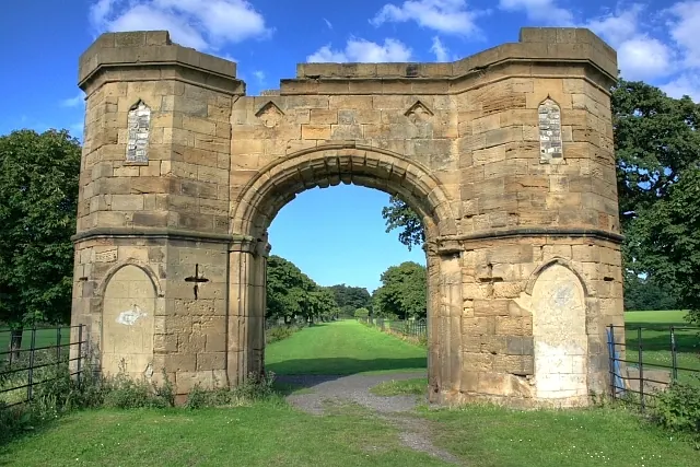
© Mick Garratt · Geograph · CC BY-SA 2.0
Images © their respective photographers, licensed under CC BY-SA 2.0 and reused here with attribution. Photographs depict listed buildings, churches and monuments near this settlement and may show neighbouring villages.
Data derived from the Open Domesday project (opendomesday.org), based on the Domesday Book dataset compiled by Professor J.J.N. Palmer and team. The Domesday Book (1086) is in the public domain.
Found an inaccuracy? [email protected]