Hungrewenitune in the Domesday Book (1086)
The settlement of Hungrewenitune is recorded in William I’s Domesday survey of 1086, entered under the hundred of Hamestan in Cheshire.
Other Settlements in Hamestan
- Adlington
- Bosley
- Bramhall
- Bredbury
- Butley
- Capesthorne
- Cheadle
- Chelford
- Cranage
- Gawsworth
- Henbury
- Hollingworth
- Kermincham
- Leighton
The Meaning of the Name
The origin of the name Hungrewenitune is not securely established from its modern form alone; like many settlement names in the North it likely combines an Old English or Old Norse personal name with a landscape term.
Remarkably, the name has changed little since 1086, when the Domesday scribes wrote it as Hungrewenitune.
Listed Buildings Near Hungrewenitune
Historic England records 37 listed buildings within about a mile of Hungrewenitune. Listing protects structures of special architectural or historic interest, graded I (exceptional), II* (particularly important) and II.
Grade I
- Church of St Peter - 0.75 km
Grade II*
- National Westminster Bank - 0.78 km
Grade II
- South Entrance Arch to Prestbury Railway Tunnel - 0.17 km
- Butley Hall - 0.48 km
- Bridge End Farmhouse - 0.49 km
- Milestone Opposite Aldersey Fold - 0.54 km
- New Road Cottage - 0.54 km
- Village Restaurant - 0.58 km
- Brooks Cottages - 0.59 km
- Admiral Rodney Inn - 0.59 km
- Lilac Cottage - 0.61 km
- Heybridge Farmhouse - 0.7 km
- Bridge Hotel - 0.73 km
- The Manor House - 0.75 km
- Yew Tree House - 0.75 km
- Chapel in St Peter’s Churchyard - 0.76 km
- Church House Ravenstone - 0.77 km
- Lychgate and West Wall of St Peter’s Churchyard - 0.77 km
- Sundial in St Peter’s Churchyard - 0.78 km
- Premises of Milligan and Nuttall and Swanwick House - 0.79 km
- Hearse House in St Peter’s Churchyard - 0.79 km
- The Stocks - 0.79 km
- K6 Telephone Kiosk to West of St Peter’s Church - 0.8 km
- Unicorn House (Premises of Peter Dominic Wine Merchants) - 0.81 km
…and 13 more listed structures in the area.
Scheduled Monuments Near Hungrewenitune
Scheduled monuments are nationally important archaeological sites given legal protection. 2 lie within roughly a mile of Hungrewenitune:
- Cross shaft in the churchyard of St Peter’s Church - 0.75 km
- Bowl barrow 60m north of junction of London Road and Bonis Hall Lane - 0.88 km
Hungrewenitune Today
Today Hungrewenitune lies within the administrative area of Cheshire East, and the settlement recorded a population of 3,359 at the 2021 census. Nine and a half centuries separate that figure from the small rural community the Domesday survey recorded here in 1086.
Read more about modern Prestbury on Wikipedia .
Nearby Domesday Settlements
Other places recorded in the 1086 survey within a few miles:
- Butley - 1.0 km E
- Mottram St Andrew - 2.8 km NW
- Adlington - 3.2 km N
- Over Alderley - 4.1 km W
- Macclesfield - 4.1 km S
- Henbury - 4.5 km SW
Heritage Around Hungrewenitune
Photographs of churches, listed buildings and monuments in the vicinity, contributed by volunteers to the Geograph project and reused here under a Creative Commons licence.
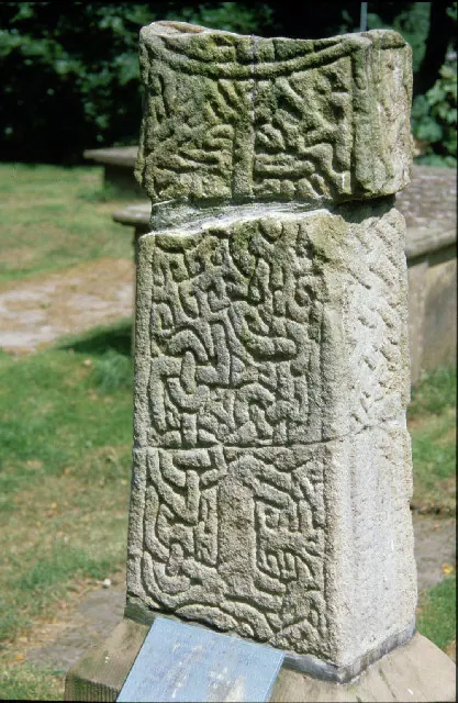
© Peter Ward · Geograph · CC BY-SA 2.0
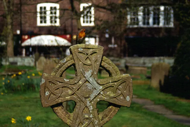
© Stephen McKay · Geograph · CC BY-SA 2.0
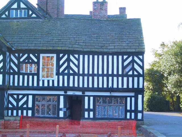
© Roger May · Geograph · CC BY-SA 2.0
Images © their respective photographers, licensed under CC BY-SA 2.0 and reused here with attribution. Photographs depict listed buildings, churches and monuments near this settlement and may show neighbouring villages.
Data derived from the Open Domesday project (opendomesday.org), based on the Domesday Book dataset compiled by Professor J.J.N. Palmer and team. The Domesday Book (1086) is in the public domain.
Found an inaccuracy? [email protected]