Higher and Lower Heysham in the Domesday Book (1086)
The settlement of Higher and Lower Heysham is recorded in William I’s Domesday survey of 1086, entered under the hundred of Amounderness in Yorkshire.
Other Settlements in Amounderness
- Aighton
- Aldcliffe
- Aldingham
- Arkholme
- Aschebi
- Ashton [Hall]
- Ashton [on Ribble]
- Austwick
- Barbon
- Bardsea
- Bare
- Barnoldswick
- Barton
- Beetham
The Meaning of the Name
The name Higher and Lower Heysham is of Anglo-Saxon origin. Its final element derives from the Old English word hām, a homestead or village. The first element is most likely a personal name or an early descriptive term, now difficult to recover with certainty. Taken together the name probably meant something close to ‘a homestead’.
Remarkably, the name has changed little since 1086, when the Domesday scribes wrote it as Higher and Lower Heysham.
Listed Buildings Near Higher and Lower Heysham
Historic England records 26 listed buildings within about a mile of Higher and Lower Heysham. Listing protects structures of special architectural or historic interest, graded I (exceptional), II* (particularly important) and II.
Grade I
- Parish Church of St Peter - 0.57 km
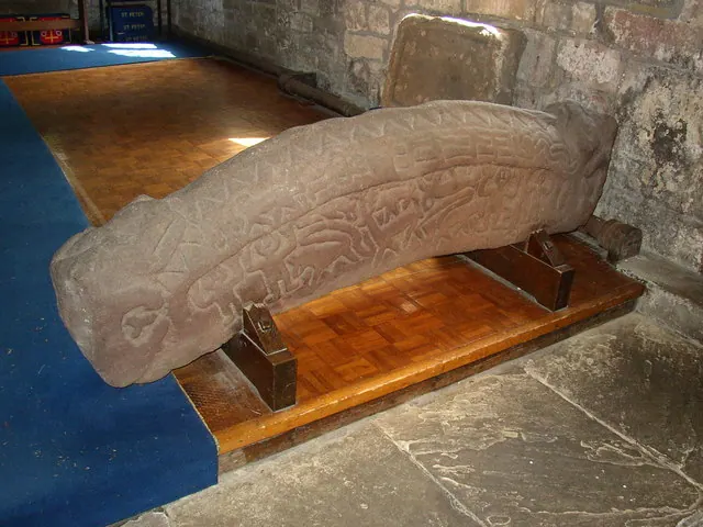
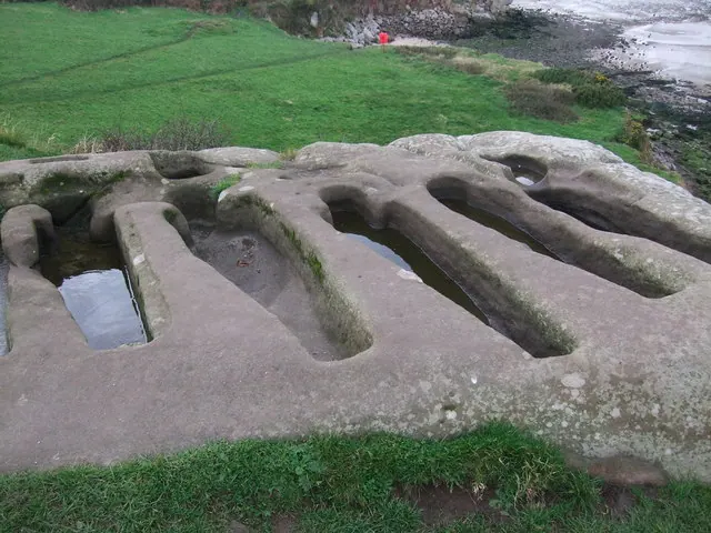
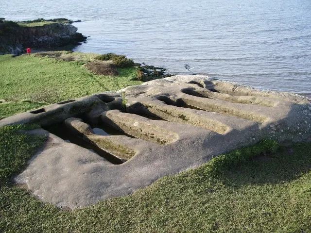
- Rock Cut Tombs Approximately 4 Metres South East of Chapel of St Patrick - 0.61 km
- Chapel of St Patrick - 0.62 km
- Rock Cut Tombs Approximately 10 Metres West of Chapel of St Patrick - 0.64 km
Grade II*
- The Old Hall Inn - 0.34 km
Grade II
- Jenny Wren Cottage - 0.38 km
- Carr Garth - 0.41 km
- Wall Enclosing 2 Sides of Garden to North of Number 18 Including Pair of Gate Piers - 0.41 km
- 40, Main Street - 0.41 km
- 19, Main Street - 0.46 km
- Shop Adjoining Number 22 to South - 0.46 km
- 8, 10 and 12, Main Street - 0.48 km
- Manor House - 0.49 km
- The Royal Hotel Including Adjoining Outbuildings - 0.49 km
- The Lodge to Heysham Head House - 0.51 km
- 1-5, Main Street - 0.51 km
- St Patrick’s Well - 0.51 km
- The Lodge - 0.53 km
- Sundial Shaft Approximately 18 Metres South of Parish Church of St Peter - 0.55 km
- Stone Coffin Approximately 12 Metres South of Parish Church of St Peter - 0.56 km
- Archway Approximately 32 Metres West South West of Parish Church of St Peter - 0.6 km
- Walling to West of Archway in Churchyard of Parish Church of St Peter - 0.61 km
- Walls on 3 Sides of Rose Garden at Heysham Head - 0.65 km
- Walls at Heysham Head to South of House - 0.68 km
…and 2 more listed structures in the area.
Scheduled Monuments Near Higher and Lower Heysham
Scheduled monuments are nationally important archaeological sites given legal protection. 2 lie within roughly a mile of Higher and Lower Heysham:
- High cross in St Peter’s churchyard, Heysham - 0.55 km
- St Patrick’s early Christian chapel and associated cemetery, Lower Heysham - 0.63 km
Higher and Lower Heysham Today
Today Higher and Lower Heysham lies within the administrative area of Lancaster, and the settlement recorded a population of 17,016 at recent figures. Nine and a half centuries separate that figure from the small rural community the Domesday survey recorded here in 1086.
Read more about modern Heysham on Wikipedia .
Nearby Domesday Settlements
Other places recorded in the 1086 survey within a few miles:
- Heaton - 3.2 km E
- Middleton - 3.2 km S
- Poulton Hall - 3.6 km NE
- Oxcliffe Hall - 4.0 km E
- Torisholme - 4.5 km NE
- Overton - 4.5 km SE
Heritage Around [Higher and Lower] Heysham
Photographs of churches, listed buildings and monuments in the vicinity, contributed by volunteers to the Geograph project and reused here under a Creative Commons licence.
© Humphrey Bolton · Geograph · CC BY-SA 2.0
© Adie Jackson · Geograph · CC BY-SA 2.0
© Alexander P Kapp · Geograph · CC BY-SA 2.0
Images © their respective photographers, licensed under CC BY-SA 2.0 and reused here with attribution. Photographs depict listed buildings, churches and monuments near this settlement and may show neighbouring villages.
Data derived from the Open Domesday project (opendomesday.org), based on the Domesday Book dataset compiled by Professor J.J.N. Palmer and team. The Domesday Book (1086) is in the public domain.
Found an inaccuracy? [email protected]