Guiseley in the Domesday Book (1086)
Guiseley appears in the Domesday Book of 1086, entered under the hundred of Skyrack in Yorkshire. The survey assessed Guiseley at 1 carucate of taxable land.
At the time of the survey, Guiseley supported a recorded population of 10 villagers, 9 smallholders, 2 slaves, working 9 ploughs between them.
The survey records Guiseley’s value at 4 shillings in 1086. No pre-Conquest figure survives – not unusual in the North, where records were disrupted by the Harrying and by the patchy coverage of the survey.
Resources Recorded at Guiseley (1086)
- Cattle: 11
- Pigs: 12
- Sheep: 100
- Meadow: 5 acres
Other Settlements in Skyrack
- Adel
- Allerton [Bywater]
- Alwoodley
- Arthington
- Austhorpe
- Baildon
- Bardsey
- Barwick [in Elmet]
- Bichertun
- Bicherun
- Bingley
- Birkby [Hill]
- Bramhope
- Burden [Head]
The Meaning of the Name
The name Guiseley is of Anglo-Saxon origin. Its final element derives from the Old English word lēah, a woodland clearing or glade. The first element is most likely a personal name or an early descriptive term, now difficult to recover with certainty. Taken together the name probably meant something close to ‘a clearing’.
Remarkably, the name has changed little since 1086, when the Domesday scribes wrote it as Guiseley.
Listed Buildings Near Guiseley
Historic England records 21 listed buildings within about a mile of Guiseley. Listing protects structures of special architectural or historic interest, graded I (exceptional), II* (particularly important) and II.
Grade I
- Church of St Oswald - 0.38 km
Grade II*
- Rectory Hall - 0.39 km
Grade II
- Upper End Farmhouse - 0.1 km
- 60 and 62, Town Street - 0.1 km
- 38, Town Street - 0.17 km
- Manor House - 0.17 km
- Manor Cottage - 0.18 km
- Guiseley Cross - 0.33 km
- Group of 5 Monuments in Angle Between Chancel and Vestry of Church of St Oswald - 0.37 km
- Padgett Tomb Chest Approximately 15 Metres South East of Church of at Oswald - 0.38 km
- Two Tomb Chests of Hannah Wilkinson and Mary Cooper on South Side of Path, Opposite South Transept of Church of St Oswald - 0.39 km
- Group of 6 Monuments in Corner of Paths Approximately 10 Metres South East of Church of St Oswald - 0.39 km
- Two Lamp-posts Beside Steps Leading to West Door of Church of St Oswald - 0.39 km
- Group of 18 Monuments on South Side of South Aisle and Transept of Church of St Oswald - 0.39 km
- Lychgate to Church of St Oswald - 0.39 km
- Lamp-post Approximately 7 Metres South West of Church of St Oswald - 0.4 km
- Monumental Slab of Elizabeth Hoppay and Adjacent Stone Coffin on South West Corner of Junction of Paths, Approximately 3 Metres South West of Porch of Church of St Oswald - 0.4 km
- Headstone to G Rhodes on South Side of Path, Approximately 7 Metres South of Porch of Church of St Oswald* - 0.4 km
- 50, Park Road - 0.81 km
- 28, Back Lane - 1.09 km
- Grange Farm Cottage - 1.29 km
Guiseley Today
Today Guiseley lies within the administrative area of Leeds, and the settlement recorded a population of 64,000 at recent figures. Nine and a half centuries separate that figure from the small rural community the Domesday survey recorded here in 1086.
Read more about modern Guiseley on Wikipedia .
Nearby Domesday Settlements
Other places recorded in the 1086 survey within a few miles:
- Yeadon - 1.4 km SE
- Little Hawksworth - 2.0 km W
- East Carlton - 3.2 km E
- Hawksworth - 3.2 km W
- Menston - 3.2 km W
- Otley - 3.2 km N
Heritage Around Guiseley
Photographs of churches, listed buildings and monuments in the vicinity, contributed by volunteers to the Geograph project and reused here under a Creative Commons licence.
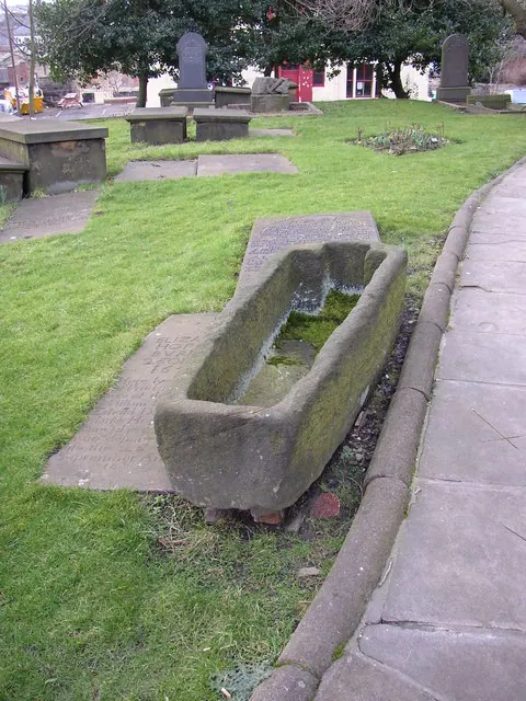
© Humphrey Bolton · Geograph · CC BY-SA 2.0
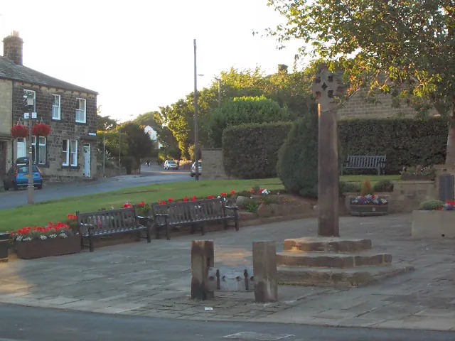
© David Spencer · Geograph · CC BY-SA 2.0
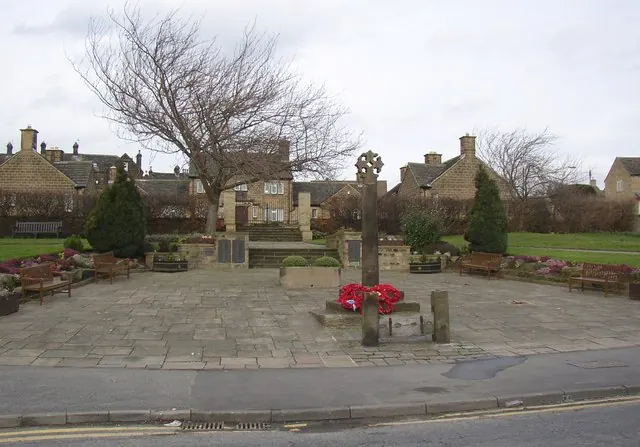
© Humphrey Bolton · Geograph · CC BY-SA 2.0
Images © their respective photographers, licensed under CC BY-SA 2.0 and reused here with attribution. Photographs depict listed buildings, churches and monuments near this settlement and may show neighbouring villages.
Data derived from the Open Domesday project (opendomesday.org), based on the Domesday Book dataset compiled by Professor J.J.N. Palmer and team. The Domesday Book (1086) is in the public domain.
Found an inaccuracy? [email protected]