Great and Little Barrow in the Domesday Book (1086)
The 1086 Domesday survey records the settlement of Great and Little Barrow, entered under the hundred of Rushton in Cheshire.
Other Settlements in Rushton
- Alpraham
- Alretone
- Ashton
- Beeston
- Bunbury and [Lower] Bunbury
- Burton
- Clotton
- Cocle
- Iddinshall
- Opetone
- Oulton
- Over
- Peckforton
- Rushton
The Meaning of the Name
The origin of the name Great and Little Barrow is not securely established from its modern form alone; like many settlement names in the North it likely combines an Old English or Old Norse personal name with a landscape term.
Remarkably, the name has changed little since 1086, when the Domesday scribes wrote it as Great and Little Barrow.
Listed Buildings Near Great and Little Barrow
Historic England records 17 listed buildings within about a mile of Great and Little Barrow. Listing protects structures of special architectural or historic interest, graded I (exceptional), II* (particularly important) and II.
Grade I
- Church of St Peter - 1.08 km
Grade II*
- Vault, Tombchest and Memorial of the Hurleston Family Attached to East End of Church of St Peter - 1.07 km
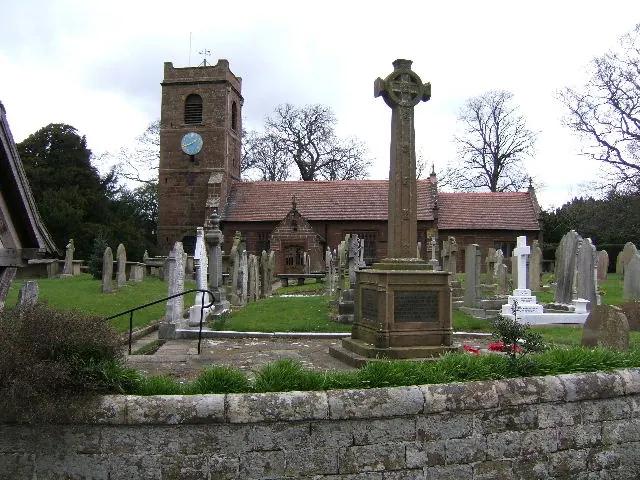
- Church of Saint Bartholomew - 1.18 km
Grade II
- Little Barrow Hall - 0.7 km
- Sundial in the Church Yard of St Peter - 1.05 km
- Bridgewater House - 1.07 km
- Pedestal Cenotaph to Thomas Cawley and Others by Chancel Door of Church of St Peter - 1.07 km
- Farmbuilding Attached to the North East Corner of Barrow Hall - 1.1 km
- West Wall and Gate of Church Yard of St Peter - 1.1 km
- Barrow Hall - 1.11 km
- L Shaped Farmbuilding Forming Courtyard at Barrow Hall - 1.14 km
- Gates Overthrow and Gate Piers to the Churchyard of St Bartholomew - 1.17 km
- The East and West Cottages Attached to the Village Hall - 1.17 km
- Sundial in St Bartholomew’s Churchyard - 1.19 km
- The Old Rectory - 1.19 km
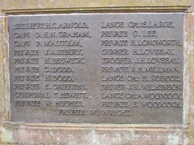
- Great Barrow War Memorial - 1.22 km
- The White House - 1.23 km
Scheduled Monuments Near Great and Little Barrow
Scheduled monuments are nationally important archaeological sites given legal protection. 2 lie within roughly a mile of Great and Little Barrow:
- Standing cross in St Bartholomew’s churchyard - 1.2 km
- St Plegmund’s Well 200m east of Bankfield Farm - 1.25 km
Great and Little Barrow Today
Today Great and Little Barrow lies within the administrative area of Cheshire West and Chester, and the settlement recorded a population of 953 at the 2021 census. Nine and a half centuries separate that figure from the small rural community the Domesday survey recorded here in 1086.
Read more about modern Barrow on Wikipedia .
Nearby Domesday Settlements
Other places recorded in the 1086 survey within a few miles:
- Mickle Trafford - 2.0 km W
- Guilden Sutton - 2.2 km SW
- Bridge Trafford - 2.2 km NW
- Tarvin - 2.8 km SE
- Dunham on the Hill - 3.2 km N
- Picton - 3.6 km NW
Heritage Around [Great and Little] Barrow
Photographs of churches, listed buildings and monuments in the vicinity, contributed by volunteers to the Geograph project and reused here under a Creative Commons licence.
© BrianPritchard · Geograph · CC BY-SA 2.0
© BrianPritchard · Geograph · CC BY-SA 2.0
© John Charlton · Geograph · CC BY-SA 2.0
Images © their respective photographers, licensed under CC BY-SA 2.0 and reused here with attribution. Photographs depict listed buildings, churches and monuments near this settlement and may show neighbouring villages.
Data derived from the Open Domesday project (opendomesday.org), based on the Domesday Book dataset compiled by Professor J.J.N. Palmer and team. The Domesday Book (1086) is in the public domain.
Found an inaccuracy? [email protected]