Ecclesfield in the Domesday Book (1086)
The 1086 Domesday survey records the settlement of Ecclesfield, entered under the hundred of Strafforth in Yorkshire. The survey assessed Ecclesfield at 16.5 carucates of taxable land.
At the time of the survey, Ecclesfield supported a recorded population of 60 villagers, 30 smallholders, 2 slaves, working 30 ploughs between them.
The survey records Ecclesfield’s value at 7 shillings in 1086. No pre-Conquest figure survives – not unusual in the North, where records were disrupted by the Harrying and by the patchy coverage of the survey.
Resources Recorded at Ecclesfield (1086)
- Mills: 1 mill (valued at 5d)
- Meadow: 27 acres
- Woodland: 1 * 0.5 leagues
Other Settlements in Strafforth
- Adwick [le Street]
- Adwick [upon Dearne]
- Armthorpe
- Aston
- Attercliffe
- Auckley
- Aughton [Hall]
- Austerfield
- Balby
- Barnbrough
- Barnby [Dun]
- Bentley
- Bilham [House]
- Billingley
The Meaning of the Name
The name Ecclesfield is of Anglo-Saxon origin. Its final element derives from the Old English word feld, open country. The first element is most likely a personal name or an early descriptive term, now difficult to recover with certainty. Taken together the name probably meant something close to ‘a open land’.
Remarkably, the name has changed little since 1086, when the Domesday scribes wrote it as Ecclesfield.
Listed Buildings Near Ecclesfield
Historic England records 13 listed buildings within about a mile of Ecclesfield. Listing protects structures of special architectural or historic interest, graded I (exceptional), II* (particularly important) and II.
Grade I
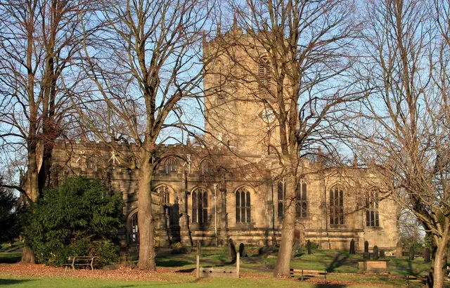
- Church of St Mary - 0.39 km
Grade II*
- The Old Hall and The Priory - 0.4 km
- Whitley Hall Hotel - 1.17 km
Grade II
- Ecclesfield War Memorial - 0.41 km
- Filemakers’ Manufactory Immediately to the North West of Number 11 - 0.48 km
- 8 and 10, Church Street - 0.48 km
- Former cruck barn attached to the south of 35 St Mary’s Lane, Ecclesfield - 0.48 km
- Court House - 0.51 km
- Ecclesfield Signal Box on Railway Lane - 1.01 km
- 269, Wheel Lane - 1.19 km
- Barn at Cowley Manor Farm on North West Side of Farmyard - 1.26 km
- Cowley Manor - 1.29 km
- Whitley Farmhouse - 1.3 km
Scheduled Monuments Near Ecclesfield
Scheduled monuments are nationally important archaeological sites given legal protection. 4 lie within roughly a mile of Ecclesfield:
- Willow Garth moated site and fishpond, Ecclesfield - 0.22 km
- Standing cross at the Church of St Mary - 0.41 km
- File factory, 11 High Street - 0.48 km
- Wayside and boundary cross on the south side of Elliott Lane - 1.21 km
Ecclesfield Today
Today Ecclesfield lies within the administrative area of Wortley Rural District, and the settlement recorded a population of 31,125 at the 2021 census. Nine and a half centuries separate that figure from the small rural community the Domesday survey recorded here in 1086.
Read more about modern Ecclesfield on Wikipedia .
Nearby Domesday Settlements
Other places recorded in the 1086 survey within a few miles:
- Thorpe Hesley - 2.8 km NE
- Grimeshou - 4.1 km S
- Wentworth - 5.0 km NE
- Wadsley - 5.0 km SW
- Kimberworth - 5.1 km E
- Tankersley - 5.1 km N
Heritage Around Ecclesfield
Photographs of churches, listed buildings and monuments in the vicinity, contributed by volunteers to the Geograph project and reused here under a Creative Commons licence.
© Geoffrey Lumb · Geograph · CC BY-SA 2.0
© Oxana Maher · Geograph · CC BY-SA 2.0
© Steve Fareham · Geograph · CC BY-SA 2.0
Images © their respective photographers, licensed under CC BY-SA 2.0 and reused here with attribution. Photographs depict listed buildings, churches and monuments near this settlement and may show neighbouring villages.
Data derived from the Open Domesday project (opendomesday.org), based on the Domesday Book dataset compiled by Professor J.J.N. Palmer and team. The Domesday Book (1086) is in the public domain.
Found an inaccuracy? [email protected]