Easby in the Domesday Book (1086)
The settlement of Easby is recorded in William I’s Domesday survey of 1086, entered under the hundred of Land of Count Alan in Yorkshire.
Other Settlements in Land of Count Alan
- Achebi
- Agglethorpe
- Ainderby [Mires]
- Ainderby [Quernhow]
- Aiskew
- Aldbrough
- Allerthorpe [Hall]
- Ascam
- Ascham
- Asebi
- Aske [Hall]
- Askrigg
- Aysgarth
- Baldersby
The Meaning of the Name
The name Easby is of Scandinavian origin. Its final element derives from the Old Norse word bý, a farmstead or village. The first element is most likely a personal name or an early descriptive term, now difficult to recover with certainty. Taken together the name probably meant something close to ‘a farmstead’.
Names of this type are a fingerprint of Scandinavian settlement: they cluster across the old Danelaw, where Norse-speaking settlers renamed or founded villages from the late 9th century onward.
Remarkably, the name has changed little since 1086, when the Domesday scribes wrote it as Easby.
Listed Buildings Near Easby
Historic England records 43 listed buildings within about a mile of Easby. Listing protects structures of special architectural or historic interest, graded I (exceptional), II* (particularly important) and II.
Grade I
- Abbey Gatehouse - 0.2 km
- Ruins of Abbey of St Agatha - 0.2 km
- Church of St Agatha - 0.21 km
- St Martins Priory Ruins - 0.88 km
Grade II*
Grade II
- The Vicarage - 0.08 km
- Coach House and Screen Wall to North-west of the Vicarage - 0.09 km
- Almshouses - 0.12 km
- Easby Mullions - 0.13 km
- Gateway to Church of St Agatha, Approximately 25 Metres North-east of Church - 0.19 km
- Monument to Thomas Wilkin Approximately 20 Metres South of South-east Corner of South Aisle of Church of St Agatha - 0.23 km
- Monument to Margaret Carter Approximately 21 Metres South of Priest’s Door of Church of St Agatha - 0.23 km
- Monument to Robert Carter Aproximately 22 Metres South of Priest’s Door of Church of St Agatha - 0.23 km
- Abbey Mill - 0.24 km
- Abbey House Ruins of Monastic Barn - 0.31 km
- St Martins House and Screen Walls - 0.41 km
- Sandford House - 0.54 km
- Boundary Stone Approximately 1 Metre East of Scots Dyke - 0.55 km
- Gateway to St Trinian’s Hall - 0.59 km
- St Trinian’s Hall - 0.65 km
- Garden Walls to North-east of St Trinian’s Hall - 0.68 km
- St Nicholas - 0.76 km
- Former Gas House - 0.88 km
- Station Cottages - 0.92 km
…and 19 more listed structures in the area.
Scheduled Monuments Near Easby
Scheduled monuments are nationally important archaeological sites given legal protection. 8 lie within roughly a mile of Easby:
- Easby Abbey Premonstratensian monastery: monastic precinct, cultivation terraces, water-management features and ancillary buildings - 0.26 km
- Section of Scots Dyke linear boundary 75m south west of Sandford House - 0.52 km
- Section of the Scots Dyke linear boundary 250m south east of St Martin’s Priory - 0.65 km
- Section of the Scots Dyke linear boundary 225m south of St Martin’s Priory - 0.82 km
- St Martin’s Benedictine Priory, Richmond - 0.87 km
- Section of Scots Dyke linear boundary and portion of field system 100m east of Whitefields Farm - 0.89 km
- Richmond Castle: eleventh to fourteenth century enclosure castle - 1.46 km
- The Bar, a surviving gateway originally part of Richmond’s medieval town wall - 1.59 km
Easby Today
Today Easby lies within the administrative area of Richmondshire, and the settlement recorded a population of 131 at the 2021 census. Nine and a half centuries separate that figure from the small rural community the Domesday survey recorded here in 1086.
Read more about modern Easby on Wikipedia .
Nearby Domesday Settlements
Other places recorded in the 1086 survey within a few miles:
Heritage Around Easby
Photographs of churches, listed buildings and monuments in the vicinity, contributed by volunteers to the Geograph project and reused here under a Creative Commons licence.
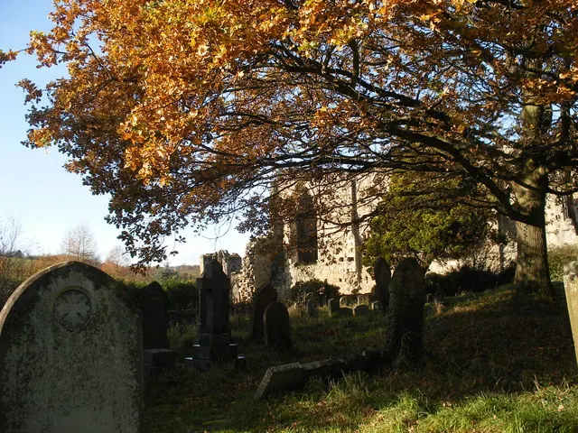
© SMJ · Geograph · CC BY-SA 2.0
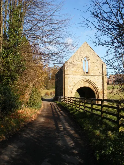
© SMJ · Geograph · CC BY-SA 2.0
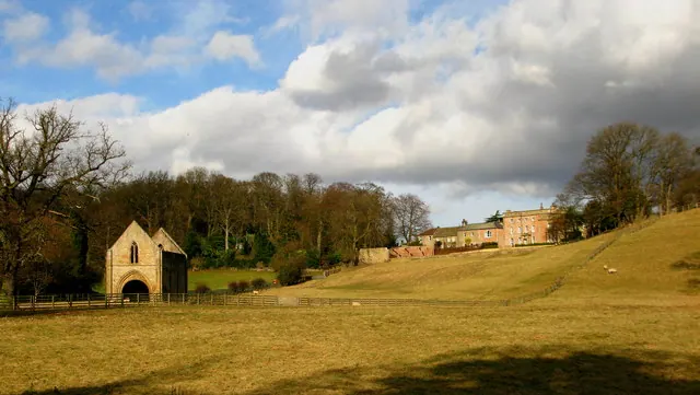
© David Rogers · Geograph · CC BY-SA 2.0
Images © their respective photographers, licensed under CC BY-SA 2.0 and reused here with attribution. Photographs depict listed buildings, churches and monuments near this settlement and may show neighbouring villages.
Location
54.3995°N, -1.7150°W · Land of Count Alan hundred, Yorkshire
View larger map on OpenStreetMap →Data derived from the Open Domesday project (opendomesday.org), based on the Domesday Book dataset compiled by Professor J.J.N. Palmer and team. The Domesday Book (1086) is in the public domain.
Found an inaccuracy? [email protected]