Cradeuuelle in the Domesday Book (1086)
The settlement of Cradeuuelle is recorded in William I’s Domesday survey of 1086, entered under the hundred of Burghshire in Yorkshire. The survey assessed Cradeuuelle at 12 carucates of taxable land.
At the time of the survey, Cradeuuelle supported a recorded population of 8 villagers, 2 smallholders, 6 slaves, working 4 ploughs between them.
The survey records Cradeuuelle’s value at 4 shillings in 1086. No pre-Conquest figure survives – not unusual in the North, where records were disrupted by the Harrying and by the patchy coverage of the survey.
Resources Recorded at Cradeuuelle (1086)
- Mills: 1 mill (valued at 2d)
- Horses (cobs): 1
- Meadow: 50 acres
- Woodland: 100 acres
Other Settlements in Burghshire
- Addlethorpe
- Aismunderby
- Aldfield
- Allerton [Mauleverer]
- Arkendale
- Askwith
- Azerley
- Barrowby [Grange]
- Beckwith [House]
- Besthaim
- Bestham
- Bewerley
- Bilton
- Birstwith
The Meaning of the Name
The origin of the name Cradeuuelle is not securely established from its modern form alone; like many settlement names in the North it likely combines an Old English or Old Norse personal name with a landscape term.
Remarkably, the name has changed little since 1086, when the Domesday scribes wrote it as Cradeuuelle.
Listed Buildings Near Cradeuuelle
Historic England records 16 listed buildings within about a mile of Cradeuuelle. Listing protects structures of special architectural or historic interest, graded I (exceptional), II* (particularly important) and II.
Grade II*
- Church of All Saints - 0.42 km
- Spofforth Castle, Ruins - 0.69 km
Grade II
- John Metcalf Memorial Approximately 15 Metres From East End of North Aisle of Church of All Saints - 0.39 km
- Packhorse Bridge Approximately 1 Metre to West of Old Corn Mill - 0.39 km
- Mounting Block - 0.41 km
- Archway With Gates and Flanking Walls and Inner, Freestanding Archway to the Old Rectory - 0.42 km
- The Old Rectory - 0.46 km
- Chantry House Massey Garth - 0.5 km
- Brookroyd Cottage - 0.52 km
- Manor House - 0.55 km
- Milepost Against North Corner of Castle Farmhouse - 0.57 km
- 26 and 28, High Street - 0.57 km
- Castle Farmhouse - 0.58 km
- 47, 49, 51 and 53, Castle Street - 0.59 km
- Aketon Close - 1.04 km
- Stables at Aketon Close - 1.07 km
Scheduled Monuments Near Cradeuuelle
Scheduled monuments are nationally important archaeological sites given legal protection. 1 lies within roughly a mile of Cradeuuelle:
- Spofforth Castle magnates’ residence - 0.63 km
Cradeuuelle Today
Today Cradeuuelle lies within the administrative area of Spofforth with Stockeld.
Read more about modern Spofforth on Wikipedia .
Nearby Domesday Settlements
Other places recorded in the 1086 survey within a few miles:
- Caldeuuelle - 0.0 km N
- Spofforth - 0.0 km N
- Newsome Farm - 1.0 km E
- Great Braham - 1.4 km NW
- Little Braham - 1.4 km NW
- Great and Little Ribston - 2.8 km NE
Heritage Around Cradeuuelle
Photographs of churches, listed buildings and monuments in the vicinity, contributed by volunteers to the Geograph project and reused here under a Creative Commons licence.
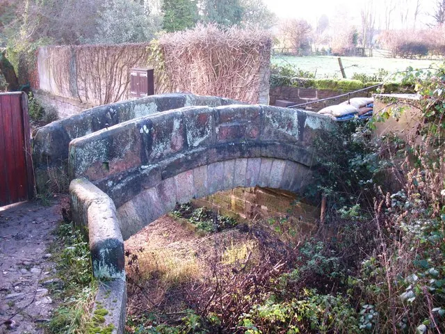
© Gordon Hatton · Geograph · CC BY-SA 2.0
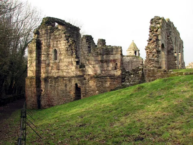
© John Sutton · Geograph · CC BY-SA 2.0
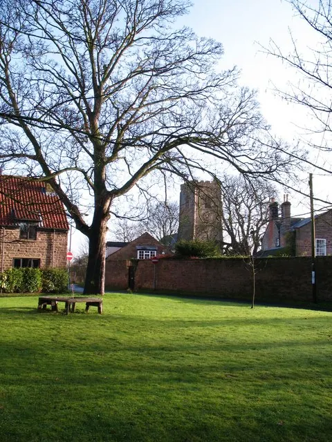
© Gordon Hatton · Geograph · CC BY-SA 2.0
Images © their respective photographers, licensed under CC BY-SA 2.0 and reused here with attribution. Photographs depict listed buildings, churches and monuments near this settlement and may show neighbouring villages.
Data derived from the Open Domesday project (opendomesday.org), based on the Domesday Book dataset compiled by Professor J.J.N. Palmer and team. The Domesday Book (1086) is in the public domain.
Found an inaccuracy? [email protected]