Colburn in the Domesday Book (1086)
The 1086 Domesday survey records the settlement of Colburn, entered under the hundred of Land of Count Alan in Yorkshire.
Other Settlements in Land of Count Alan
- Achebi
- Agglethorpe
- Ainderby [Mires]
- Ainderby [Quernhow]
- Aiskew
- Aldbrough
- Allerthorpe [Hall]
- Ascam
- Ascham
- Asebi
- Aske [Hall]
- Askrigg
- Aysgarth
- Baldersby
The Meaning of the Name
The origin of the name Colburn is not securely established from its modern form alone; like many settlement names in the North it likely combines an Old English or Old Norse personal name with a landscape term.
Remarkably, the name has changed little since 1086, when the Domesday scribes wrote it as Colburn.
Listed Buildings Near Colburn
Historic England records 20 listed buildings within about a mile of Colburn. Listing protects structures of special architectural or historic interest, graded I (exceptional), II* (particularly important) and II.
Grade I
- Courthouse to East of Colburn Hall - 0.25 km
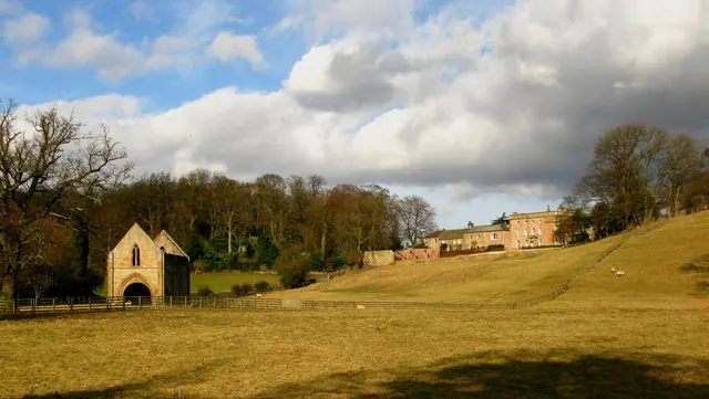
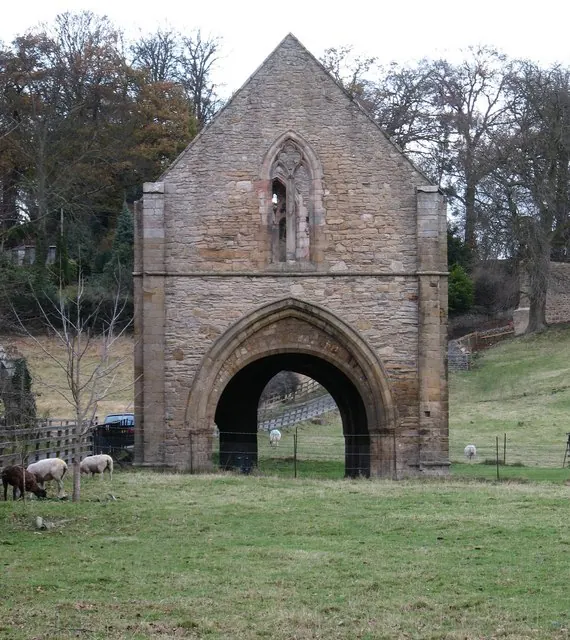
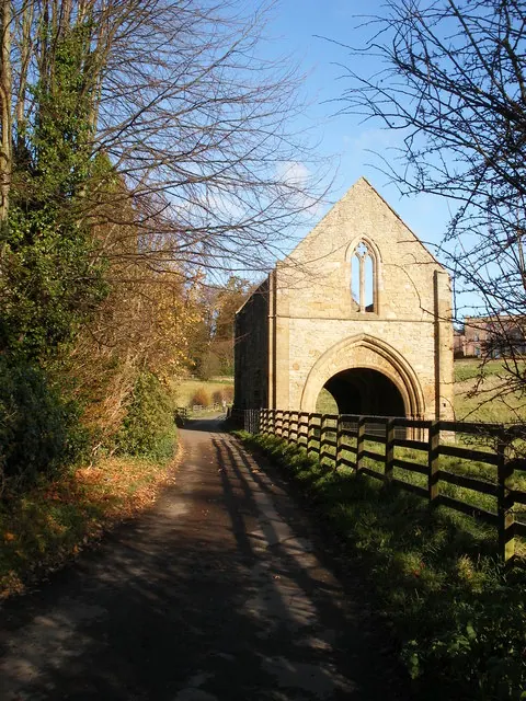
- Abbey Gatehouse - 1.28 km
Grade II*
- Colburn Hall - 0.25 km
- Easby Hall and Numbers 1 and 2 Easby Court - 1.25 km
Grade II
- Barn Attached to East Side of the Courthouse - 0.25 km
- Cherry Tree Cottage - 0.35 km
- Farm Buildings at Colburn Farm - 0.41 km
- Broken Brea Crossing Cottage - 1.04 km
- St Trinian’s Hall - 1.14 km
- Gateway to St Trinian’s Hall - 1.15 km
- Garden Walls to North-east of St Trinian’s Hall - 1.21 km
- Outbuildings to East of Hipswell Mill - 1.26 km
- Hipswell Mill Millhouse - 1.27 km
- Barn Approximately 15 Metres North of Hipswell Hall - 1.27 km
- Abbey House Ruins of Monastic Barn - 1.28 km
- Gateway to Church of St Agatha, Approximately 25 Metres North-east of Church - 1.29 km
- Easby Mullions - 1.29 km
- Monument to Thomas Wilkin Approximately 20 Metres South of South-east Corner of South Aisle of Church of St Agatha - 1.29 km
- Monument to Margaret Carter Approximately 21 Metres South of Priest’s Door of Church of St Agatha - 1.29 km
- Monument to Robert Carter Aproximately 22 Metres South of Priest’s Door of Church of St Agatha - 1.29 km
Scheduled Monuments Near Colburn
Scheduled monuments are nationally important archaeological sites given legal protection. 2 lie within roughly a mile of Colburn:
- Easby Abbey Premonstratensian monastery: monastic precinct, cultivation terraces, water-management features and ancillary buildings - 1.24 km
- St Giles medieval hospital, post-medieval farmstead and Iron Age occupation site immediately north of St Giles Farm - 1.38 km
Colburn Today
Today Colburn lies within the administrative area of Richmondshire, and the settlement recorded a population of 5,472 at the 2021 census. Nine and a half centuries separate that figure from the small rural community the Domesday survey recorded here in 1086.
Read more about modern Colburn on Wikipedia .
Nearby Domesday Settlements
Other places recorded in the 1086 survey within a few miles:
- Hipswell - 1.4 km SW
- Easby - 1.4 km NW
- Brompton on Swale - 2.0 km E
- Richmond - 2.8 km NW
- Brough Hall - 2.8 km SE
- Skeeby - 3.2 km N
Heritage Around Colburn
Photographs of churches, listed buildings and monuments in the vicinity, contributed by volunteers to the Geograph project and reused here under a Creative Commons licence.
© David Rogers · Geograph · CC BY-SA 2.0
© Gordon Hatton · Geograph · CC BY-SA 2.0
© SMJ · Geograph · CC BY-SA 2.0
Images © their respective photographers, licensed under CC BY-SA 2.0 and reused here with attribution. Photographs depict listed buildings, churches and monuments near this settlement and may show neighbouring villages.
Location
54.3904°N, -1.6997°W · Land of Count Alan hundred, Yorkshire
View larger map on OpenStreetMap →Data derived from the Open Domesday project (opendomesday.org), based on the Domesday Book dataset compiled by Professor J.J.N. Palmer and team. The Domesday Book (1086) is in the public domain.
Found an inaccuracy? [email protected]