Broughton in Furness in the Domesday Book (1086)
Broughton in Furness is named in the Domesday Book, compiled by Norman commissioners in 1086, entered under the hundred of Amounderness in Yorkshire.
Other Settlements in Amounderness
- Aighton
- Aldcliffe
- Aldingham
- Arkholme
- Aschebi
- Ashton [Hall]
- Ashton [on Ribble]
- Austwick
- Barbon
- Bardsea
- Bare
- Barnoldswick
- Barton
- Beetham
The Meaning of the Name
The name Broughton in Furness is of Anglo-Saxon origin. Its final element derives from the Old English word tūn, a farmstead or village. The first element is most likely a personal name or an early descriptive term, now difficult to recover with certainty. Taken together the name probably meant something close to ‘a farmstead’.
Remarkably, the name has changed little since 1086, when the Domesday scribes wrote it as Broughton in Furness.
Listed Buildings Near Broughton in Furness
Historic England records 25 listed buildings within about a mile of Broughton in Furness. Listing protects structures of special architectural or historic interest, graded I (exceptional), II* (particularly important) and II.
Grade II*
- Obelisk and Stocks - 0.64 km
- Broughton Tower Special School - 0.92 km
- Duddon Iron Furnace - 1.24 km
Grade II
- Cottage and Farm Buildings Opposite Syke House - 0.34 km
- Syke House and Syke House Cottage - 0.35 km
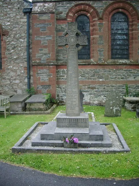
- Church of St Mary Magdalene - 0.36 km
- Sundial Approximately 13.5 Metres to South of St Mary’s Church - 0.37 km
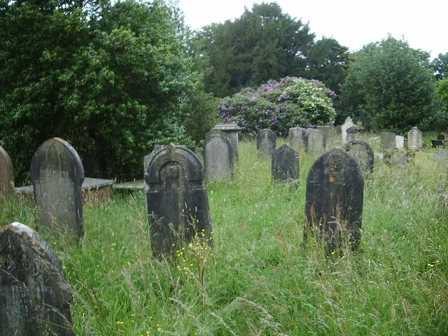
- Group of 4 Tombs Approximately 14 Metres to South of St Mary’s Church - 0.38 km
- Atkinson Monument Approximately 10.5 Metres to South of St Mary’s Church - 0.4 km
- Old King’s Head Public House - 0.55 km
- Broughton House - 0.57 km
- Cobblers Cottage and Former Broughton Craft Shop - 0.58 km
- Black Cock Inn - 0.61 km
- Grovelands and Adjoining House - 0.61 km
- Beswick’s Restaurant and Cafe - 0.62 km
- Market Hall - 0.62 km
- The Square Cafe, Hillside and Aitken House - 0.63 km
- 1-5, the Square - 0.64 km
- Two Market Benches to East of Obelisk - 0.65 km
- Terrace of Six Houses - 0.66 km
- Gateway to Broughton Tower - 0.66 km
- Terrace of 7 Houses and Manor Arms Public House (Deleted 14/6/68) - 0.67 km
- Duddon Bridge - 0.96 km
- Gate and Gate Piers Approximately 67 Metres to North of Broughton Tower - 0.98 km
…and 1 more listed structures in the area.
Scheduled Monuments Near Broughton in Furness
Scheduled monuments are nationally important archaeological sites given legal protection. 1 lies within roughly a mile of Broughton in Furness:
Broughton in Furness Today
Today Broughton in Furness lies within the administrative area of Broughton West, and the settlement recorded a population of 529 at recent figures. Nine and a half centuries separate that figure from the small rural community the Domesday survey recorded here in 1086.
Read more about modern Broughton in Furness on Wikipedia .
Nearby Domesday Settlements
Other places recorded in the 1086 survey within a few miles:
- Kirkby Ireleth - 5.8 km SE
- Millom Castle - 6.7 km SW
- Millom - 7.6 km S
- Whicham - 8.6 km SW
- Kirksanton - 9.2 km SW
- Bootle - 10.0 km W
Heritage Around Broughton [in Furness]
Photographs of churches, listed buildings and monuments in the vicinity, contributed by volunteers to the Geograph project and reused here under a Creative Commons licence.
© Alexander P Kapp · Geograph · CC BY-SA 2.0
© Alexander P Kapp · Geograph · CC BY-SA 2.0
© Andrew Hill · Geograph · CC BY-SA 2.0
Images © their respective photographers, licensed under CC BY-SA 2.0 and reused here with attribution. Photographs depict listed buildings, churches and monuments near this settlement and may show neighbouring villages.
Data derived from the Open Domesday project (opendomesday.org), based on the Domesday Book dataset compiled by Professor J.J.N. Palmer and team. The Domesday Book (1086) is in the public domain.
Found an inaccuracy? [email protected]