Bradley in the Domesday Book (1086)
Bradley appears in the Domesday Book of 1086, entered under the hundred of Agbrigg in Yorkshire. The survey assessed Bradley at 2.2 carucates of taxable land.
The survey records Bradley’s value at 0d in 1086. No pre-Conquest figure survives – not unusual in the North, where records were disrupted by the Harrying and by the patchy coverage of the survey.
Other Settlements in Agbrigg
- Ackton
- Almondbury
- Austonley
- Cartworth
- Crigglestone
- Crofton
- Dalton
- Emley
- Farnley [Tyas]
- Flockton
- Fulstone
- Golcar
- Hepworth
- Holme
The Meaning of the Name
The name Bradley is of Anglo-Saxon origin. Its final element derives from the Old English word lēah, a woodland clearing or glade. The first element is most likely a personal name or an early descriptive term, now difficult to recover with certainty. Taken together the name probably meant something close to ‘a clearing’.
Remarkably, the name has changed little since 1086, when the Domesday scribes wrote it as Bradley.
Listed Buildings Near Bradley
Historic England records 30 listed buildings within about a mile of Bradley. Listing protects structures of special architectural or historic interest, graded I (exceptional), II* (particularly important) and II.
Grade II
- Calder and Hebble Navigation Cooper Bridge Lock Kirklees Cut Cooper Bridge Lock - 0.1 km
- Calder and Hebble Navigation Lock Keepers Cottage at Cooper Bridge Lock Sir John Ramsdens Canal Lock Keepers Cottage at Cooper Bridge Lock - 0.1 km
- Lilac Cottage - 0.17 km
- Calder and Hebble Navigation Number 2 Lock Sir John Ramsdens Canal Number 2 Lock - 0.2 km
- Railway overbridge MVL3/107, Colne Bridge (B1168 Bridge Road) - 0.2 km
- Calder and Hebble Navigation Wharfe Works - 0.22 km
- Calder and Hebble Navigation Cooper Bridge Lock-keepers House - 0.24 km
- Calder and Hebble Navigation Cooper Bridge Lock and Gantry to Foot Bridge - 0.25 km
- Calder and Hebble Navigation Bridge Taking Colne Bridge Road Sir John Ramsdens Canal Bridge Taking Colne Bridge Road - 0.26 km
- Colne Bridge Mill - 0.29 km
- Calder and Hebble Navigation Cooper Bridge Floodgate - 0.3 km
- Colne Bridge - 0.34 km
- Former Church of St Thomas - 0.47 km
- 33-37, Oak Road - 0.48 km
- Gatepiers of Church of St Thomas - 0.5 km
- The Dumb Steeple - 0.65 km
- 142, Bradley Road - 0.73 km
- Pandam Aram Farmhouse - 0.79 km
- Railway overbridge MVL3/103, Colliery Lane (Wheatleys) - 0.79 km
- Boundary Stone Opposite Three Nuns Public House - 0.82 km
- Barn to no 164 (Bradley Grange) - 0.84 km
- Bradley Grange - 0.84 km
- Bradley Hall - 0.92 km
- Calder and Hebble Navigation Johnsons Lock Sir John Ramsdens Canal Johnsons Lock - 0.93 km
…and 6 more listed structures in the area.
Scheduled Monuments Near Bradley
Scheduled monuments are nationally important archaeological sites given legal protection. 1 lies within roughly a mile of Bradley:
Bradley Today
Today Bradley lies within the administrative area of Kirklees.
Read more about modern Bradley on Wikipedia .
Nearby Domesday Settlements
Other places recorded in the 1086 survey within a few miles:
- Hartshead - 2.2 km NE
- Clifton - 2.2 km NW
- Upper Hopton - 2.8 km SE
- Mirfield - 3.0 km E
- Kirkheaton - 3.2 km S
- Liversedge - 3.6 km NE
Heritage Around Bradley
Photographs of churches, listed buildings and monuments in the vicinity, contributed by volunteers to the Geograph project and reused here under a Creative Commons licence.
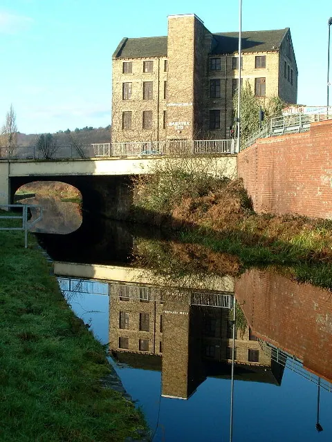
© Nigel Homer · Geograph · CC BY-SA 2.0
© Humphrey Bolton · Geograph · CC BY-SA 2.0
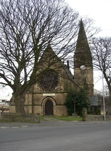
© Humphrey Bolton · Geograph · CC BY-SA 2.0
Images © their respective photographers, licensed under CC BY-SA 2.0 and reused here with attribution. Photographs depict listed buildings, churches and monuments near this settlement and may show neighbouring villages.
Data derived from the Open Domesday project (opendomesday.org), based on the Domesday Book dataset compiled by Professor J.J.N. Palmer and team. The Domesday Book (1086) is in the public domain.
Found an inaccuracy? [email protected]